Las Mesas geodata
Las Mesas (Veracruz) is a populated place; located in Mexico in America/Mexico_City (GMT-6) time zone. With population of 568 people, there are 15043 cities with bigger population in this country. Compared to other cities in Mexico, 76.3% of cities are located further ↑North; 82.9% of cities are located further ←West and 94% of cities have higher elevation than Las Mesas. Note1


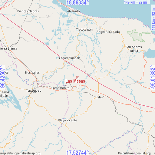
Las Mesas GPS coordinates[2]
18° 11' 48.012" North, 95° 43' 18.984" West
| Map corner | latitude | longitude |
|---|---|---|
| Upper-left | 18.86334°, | -96.42507° |
| Center: | 18.19667°, | -95.72194° |
| Lower-right: | 17.52744°, | -95.01882° |
| Map W x H: | 148.5×148.5 km | = 92.3×92.3mi |
| max Lat: | 32.7° ⇑76.3% North |
| Las Mesas: | 18.19667° |
| min Lat: | ⇓23.7% South 14.53588° |
| min Long | Las Mesas | max Long |
| -117.105° | -95.72194° | -86.73105° |
| W 82.9%⇐ | ⇒17.1% E |
Elevation
Elevation of Las Mesas is 15 m = 49 ft, and this is 1238.7 m = 4064 ft below average elevation for this country.
| Max E: |
3497 m = 11473 ft | 94% |
| Avg. | 1253.7 m = 4113 ft | |
| Las Mesas | 15 m = 49 ft | |
Min E: |
-1 m = -3 ft | 6% |
See also: Mexico elevation on elevation.city.
Geographical zone
Las Mesas is located in North Torrid zone (between Equator and Tropic of Cancer). Distance of this Northern Tropic circle is 582.6 km =362 mi to North.| Distance of | km | miles | from Las Mesas |
|---|---|---|---|
| North Pole | 7983.8 | 4960.9 | to North |
| Arctic Circle | 5377.9 | 3341.7 | to North |
| Tropic Cancer | 582.6 | 362 | to North |
| Equator | 2023.3 | 1257.2 | to South |


Nearby cities:
15 places around Las Mesas: (largest is in red/bold)
• Arroyo del Soldado (Arroyo del Obispo)
14.5 km =9 mi,  335°
335°
• Cerro Colorado
17 km =10.6 mi,  307°
307°
• Cujuliapan
7.2 km =4.5 mi,  85°
85°
• Curazao
11.2 km =7 mi,  160°
160°
• El Maguey
14 km =8.7 mi,  170°
170°
• Estación Dobladero
10.2 km =6.3 mi,  207°
207°
• Juan García
12 km =7.5 mi,  44°
44°
• Las Sabanetas
13.2 km =8.2 mi,  233°
233°
• Lindavista
13.3 km =8.3 mi, 205°
• Mata de Caña
12.5 km =7.8 mi,  279°
279°
• Nuevo Potrero
15.8 km =9.8 mi,  130°
130°
• Tesechoacan
9.4 km =5.8 mi, 134°
• Tilapa
13.6 km =8.5 mi, 342°
• Vicente Guerrero (El Aguacate)
5 km =3.1 mi,  47°
47°
• Villa Azueta
13.7 km =8.5 mi,  175°
175°
Sources, notices
• [Note1] Compared only with cities in Mexico existing in our database
• [Src1] Map data: © OpenStreetMap contributors (CC-BY-SA)
• [Src2] Other city data from geonames.org with taken over terms of usage.
• [Src3] Geographical zone / Annual Mean Temperature by Robert A. Rohde @ Wikipedia
