Zacalaca geodata
Zacalaca (Quintana Roo) is a populated place; located in Mexico in America/Cancun (GMT-5) time zone. With population of 1,010 people, there are 8622 cities with bigger population in this country. Compared to other cities in Mexico, 58.4% of cities are located further ↓South; 99.1% of cities are located further ←West and 87.2% of cities have higher elevation than Zacalaca. Note1


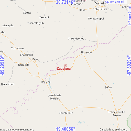
Zacalaca GPS coordinates[2]
20° 3' 44.64" North, 88° 35' 45.816" West
| Map corner | latitude | longitude |
|---|---|---|
| Upper-left | 20.72146°, | -89.29919° |
| Center: | 20.0624°, | -88.59606° |
| Lower-right: | 19.40056°, | -87.89294° |
| Map W x H: | 146.9×146.9 km | = 91.3×91.3mi |
| max Lat: | 32.7° ⇑41.6% North |
| Zacalaca: | 20.0624° |
| min Lat: | ⇓58.4% South 14.53588° |
| min Long | Zacalaca | max Long |
| -117.105° | -88.59606° | -86.73105° |
| W 99.1%⇐ | ⇒0.90000000000001% E |
Elevation
Elevation of Zacalaca is 33 m = 108 ft, and this is 1220.7 m = 4005 ft below average elevation for this country.
| Max E: |
3497 m = 11473 ft | 87.2% |
| Avg. | 1253.7 m = 4113 ft | |
| Zacalaca | 33 m = 108 ft | |
Min E: |
-1 m = -3 ft | 12.8% |
See also: Mexico elevation on elevation.city.
Geographical zone
Zacalaca is located in North Torrid zone (between Equator and Tropic of Cancer). Distance of this Northern Tropic circle is 375.2 km =233.1 mi to North.| Distance of | km | miles | from Zacalaca |
|---|---|---|---|
| North Pole | 7776.3 | 4832 | to North |
| Arctic Circle | 5170.4 | 3212.7 | to North |
| Tropic Cancer | 375.2 | 233.1 | to North |
| Equator | 2230.7 | 1386.1 | to South |


Nearby cities:
15 places around Zacalaca: (largest is in red/bold)
• Bulukax
21.4 km =13.3 mi,  239°
239°
• Chikindzonot
32.3 km =20.1 mi,  20°
20°
• Dziuche
28.9 km =18 mi,  230°
230°
• Ekpedz
33.1 km =20.6 mi,  31°
31°
• Filomeno Mata
30.9 km =19.2 mi,  137°
137°
• Huay Max
7.7 km =4.8 mi,  107°
107°
• Ichmul
11.2 km =7 mi,  353°
353°
• La Esperanza
22.1 km =13.7 mi,  177°
177°
• La Presumida
33.4 km =20.8 mi,  209°
209°
• Saban
6.7 km =4.2 mi,  117°
117°
• San Diego
27.9 km =17.3 mi, 209°
• Santa Gertrudis
34.5 km =21.4 mi, 212°
• Tiholop
31.6 km =19.6 mi,  341°
341°
• Tihosuco
27.6 km =17.1 mi,  57°
57°
• X Cabil
17.9 km =11.1 mi,  50°
50°
Sources, notices
• [Note1] Compared only with cities in Mexico existing in our database
• [Src1] Map data: © OpenStreetMap contributors (CC-BY-SA)
• [Src2] Other city data from geonames.org with taken over terms of usage.
• [Src3] Geographical zone / Annual Mean Temperature by Robert A. Rohde @ Wikipedia
