Cuautlapán geodata
Cuautlapán (Veracruz) is a populated place; located in Mexico in America/Mexico_City (GMT-6) time zone. With population of 7,549 people, there are 1236 cities with bigger population in this country. Compared to other cities in Mexico, 67.5% of cities are located further ↑North; 74.5% of cities are located further ←West and 60.1% of cities have higher elevation than Cuautlapán. Note1


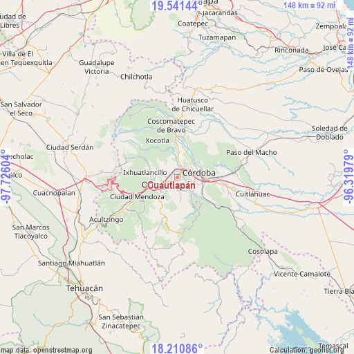
Cuautlapán GPS coordinates[2]
18° 52' 38.892" North, 97° 1' 22.476" West
| Map corner | latitude | longitude |
|---|---|---|
| Upper-left | 19.54144°, | -97.72604° |
| Center: | 18.87747°, | -97.02291° |
| Lower-right: | 18.21086°, | -96.31979° |
| Map W x H: | 147.9×147.9 km | = 91.9×91.9mi |
| max Lat: | 32.7° ⇑67.5% North |
| Cuautlapán: | 18.87747° |
| min Lat: | ⇓32.5% South 14.53588° |
| min Long | Cuautlapán | max Long |
| -117.105° | -97.02291° | -86.73105° |
| W 74.5%⇐ | ⇒25.5% E |
Elevation
Elevation of Cuautlapán is 998 m = 3274 ft, and this is 255.7 m = 839 ft below average elevation for this country.
| Max E: |
3497 m = 11473 ft | 60.1% |
| Avg. | 1253.7 m = 4113 ft | |
| Cuautlapán | 998 m = 3274 ft | |
Min E: |
-1 m = -3 ft | 39.9% |
See also: Mexico elevation on elevation.city.
Geographical zone
Cuautlapán is located in North Torrid zone (between Equator and Tropic of Cancer). Distance of this Northern Tropic circle is 506.9 km =315 mi to North.| Distance of | km | miles | from Cuautlapán |
|---|---|---|---|
| North Pole | 7908.1 | 4913.9 | to North |
| Arctic Circle | 5302.2 | 3294.6 | to North |
| Tropic Cancer | 506.9 | 315 | to North |
| Equator | 2099 | 1304.3 | to South |


Nearby cities:
15 places around Cuautlapán: (largest is in red/bold)
• Buenavista
2.3 km =1.4 mi,  319°
319°
• Campo Chico
4.6 km =2.9 mi,  186°
186°
• Coapichapan (Barranca de San Miguel)
2.4 km =1.5 mi,  65°
65°
• Colorines
4.8 km =3 mi,  80°
80°
• Cumbre de Metlac
5.4 km =3.4 mi,  356°
356°
• El Pueblito
5.7 km =3.5 mi, 79°
• Fortín de las Flores
4.2 km =2.6 mi,  35°
35°
• Fraccionamiento Villas de la Llave
5.4 km =3.4 mi, 38°
• Fredepo
4.8 km =3 mi,  85°
85°
• Ixtaczoquitlán
4.9 km =3 mi,  237°
237°
• Lagunilla
5 km =3.1 mi, 317°
• Moyoapan
5 km =3.1 mi,  331°
331°
• Sumidero
2.9 km =1.8 mi,  2°
2°
• Villa Unión
5 km =3.1 mi,  121°
121°
• Zapoapan
5.2 km =3.2 mi,  142°
142°
Sources, notices
• [Note1] Compared only with cities in Mexico existing in our database
• [Src1] Map data: © OpenStreetMap contributors (CC-BY-SA)
• [Src2] Other city data from geonames.org with taken over terms of usage.
• [Src3] Geographical zone / Annual Mean Temperature by Robert A. Rohde @ Wikipedia
