Zapoapan geodata
Zapoapan (Veracruz) is a populated place; located in Mexico in America/Mexico_City (GMT-6) time zone. With population of 2,716 people, there are 3256 cities with bigger population in this country. Compared to other cities in Mexico, 68.1% of cities are located further ↑North; 74.9% of cities are located further ←West and 63.2% of cities have higher elevation than Zapoapan. Note1


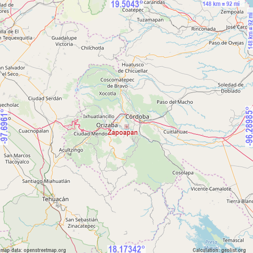
Zapoapan GPS coordinates[2]
18° 50' 24.648" North, 96° 59' 34.692" West
| Map corner | latitude | longitude |
|---|---|---|
| Upper-left | 19.5043°, | -97.6961° |
| Center: | 18.84018°, | -96.99297° |
| Lower-right: | 18.17342°, | -96.28985° |
| Map W x H: | 148×148 km | = 92×92mi |
| max Lat: | 32.7° ⇑68.1% North |
| Zapoapan: | 18.84018° |
| min Lat: | ⇓31.9% South 14.53588° |
| min Long | Zapoapan | max Long |
| -117.105° | -96.99297° | -86.73105° |
| W 74.9%⇐ | ⇒25.1% E |
Elevation
Elevation of Zapoapan is 806 m = 2644 ft, and this is 447.7 m = 1469 ft below average elevation for this country.
| Max E: |
3497 m = 11473 ft | 63.2% |
| Avg. | 1253.7 m = 4113 ft | |
| Zapoapan | 806 m = 2644 ft | |
Min E: |
-1 m = -3 ft | 36.8% |
See also: Mexico elevation on elevation.city.
Geographical zone
Zapoapan is located in North Torrid zone (between Equator and Tropic of Cancer). Distance of this Northern Tropic circle is 511.1 km =317.6 mi to North.| Distance of | km | miles | from Zapoapan |
|---|---|---|---|
| North Pole | 7912.2 | 4916.4 | to North |
| Arctic Circle | 5306.3 | 3297.2 | to North |
| Tropic Cancer | 511.1 | 317.6 | to North |
| Equator | 2094.8 | 1301.6 | to South |


Nearby cities:
15 places around Zapoapan: (largest is in red/bold)
• Campo Chico
3.7 km =2.3 mi,  263°
263°
• Campo Grande
2.8 km =1.7 mi,  227°
227°
• Capoluca
5.2 km =3.2 mi,  223°
223°
• Coapichapan (Barranca de San Miguel)
5.2 km =3.2 mi,  349°
349°
• Colorines
5.2 km =3.2 mi,  17°
17°
• Cuautlapán
5.2 km =3.2 mi,  322°
322°
• Cuesta del Mexicano
4 km =2.5 mi,  175°
175°
• Fredepo
4.8 km =3 mi, 20°
• Fresnal
2.7 km =1.7 mi,  156°
156°
• Naranjal
4.6 km =2.9 mi,  135°
135°
• San José de Tapia
4.2 km =2.6 mi,  79°
79°
• Trapiche Viejo
5 km =3.1 mi,  86°
86°
• Veinte de Noviembre
4.9 km =3 mi,  55°
55°
• Villa Libertad
4.8 km =3 mi,  126°
126°
• Villa Unión
1.9 km =1.2 mi,  35°
35°
Sources, notices
• [Note1] Compared only with cities in Mexico existing in our database
• [Src1] Map data: © OpenStreetMap contributors (CC-BY-SA)
• [Src2] Other city data from geonames.org with taken over terms of usage.
• [Src3] Geographical zone / Annual Mean Temperature by Robert A. Rohde @ Wikipedia
