Buenavista geodata
Buenavista (Veracruz) is a populated place; located in Mexico in America/Mexico_City (GMT-6) time zone. With population of 2,090 people, there are 4173 cities with bigger population in this country. Compared to other cities in Mexico, 67.2% of cities are located further ↑North; 74.4% of cities are located further ←West and 58% of cities have higher elevation than Buenavista. Note1


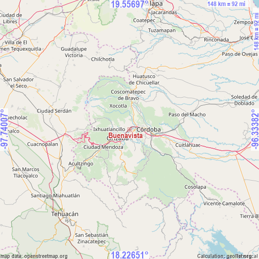
Buenavista GPS coordinates[2]
18° 53' 35.016" North, 97° 2' 12.984" West
| Map corner | latitude | longitude |
|---|---|---|
| Upper-left | 19.55697°, | -97.74007° |
| Center: | 18.89306°, | -97.03694° |
| Lower-right: | 18.22651°, | -96.33382° |
| Map W x H: | 147.9×147.9 km | = 91.9×91.9mi |
| max Lat: | 32.7° ⇑67.2% North |
| Buenavista: | 18.89306° |
| min Lat: | ⇓32.8% South 14.53588° |
| min Long | Buenavista | max Long |
| -117.105° | -97.03694° | -86.73105° |
| W 74.4%⇐ | ⇒25.6% E |
Elevation
Elevation of Buenavista is 1102 m = 3615 ft, and this is 151.7 m = 498 ft below average elevation for this country.
| Max E: |
3497 m = 11473 ft | 58% |
| Avg. | 1253.7 m = 4113 ft | |
| Buenavista | 1102 m = 3615 ft | |
Min E: |
-1 m = -3 ft | 42% |
See also: Mexico elevation on elevation.city.
Geographical zone
Buenavista is located in North Torrid zone (between Equator and Tropic of Cancer). Distance of this Northern Tropic circle is 505.2 km =313.9 mi to North.| Distance of | km | miles | from Buenavista |
|---|---|---|---|
| North Pole | 7906.4 | 4912.8 | to North |
| Arctic Circle | 5300.5 | 3293.6 | to North |
| Tropic Cancer | 505.2 | 313.9 | to North |
| Equator | 2100.7 | 1305.3 | to South |


Nearby cities:
15 places around Buenavista: (largest is in red/bold)
• Atzacan
5.1 km =3.2 mi,  287°
287°
• Coapichapan (Barranca de San Miguel)
3.8 km =2.4 mi,  101°
101°
• Colorines
6.2 km =3.9 mi, 98°
• Cuautlapán
2.3 km =1.4 mi,  139°
139°
• Cumbre de Metlac
3.8 km =2.4 mi,  17°
17°
• Córdoba (Santa Leticia)
6.3 km =3.9 mi,  74°
74°
• Dos Ríos
5.9 km =3.7 mi,  8°
8°
• Fortín de las Flores
4.2 km =2.6 mi, 66°
• Fraccionamiento Villas de la Llave
5.4 km =3.4 mi,  62°
62°
• Ixtaczoquitlán
5.1 km =3.2 mi,  211°
211°
• Lagunilla
2.8 km =1.7 mi,  315°
315°
• Monte Salas
5.3 km =3.3 mi, 21°
• Moyoapan
2.8 km =1.7 mi,  340°
340°
• Revolución
5.8 km =3.6 mi,  264°
264°
• Sumidero
2 km =1.2 mi,  53°
53°
Sources, notices
• [Note1] Compared only with cities in Mexico existing in our database
• [Src1] Map data: © OpenStreetMap contributors (CC-BY-SA)
• [Src2] Other city data from geonames.org with taken over terms of usage.
• [Src3] Geographical zone / Annual Mean Temperature by Robert A. Rohde @ Wikipedia
