Moyoapan geodata
Moyoapan (Veracruz) is a populated place; located in Mexico in America/Mexico_City (GMT-6) time zone. With population of 2,073 people, there are 4207 cities with bigger population in this country. Compared to other cities in Mexico, 66.6% of cities are located further ↑North; 74.3% of cities are located further ←West and 55.3% of cities have higher elevation than Moyoapan. Note1


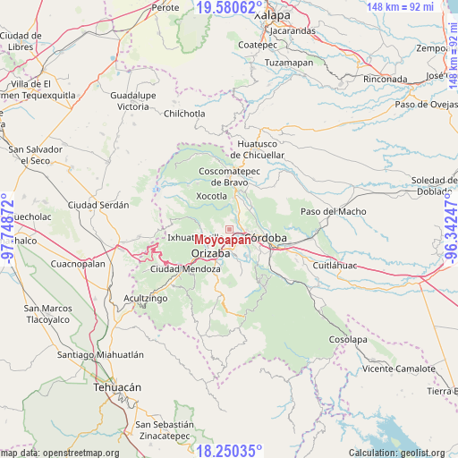
Moyoapan GPS coordinates[2]
18° 55' 0.516" North, 97° 2' 44.124" West
| Map corner | latitude | longitude |
|---|---|---|
| Upper-left | 19.58062°, | -97.74872° |
| Center: | 18.91681°, | -97.04559° |
| Lower-right: | 18.25035°, | -96.34247° |
| Map W x H: | 147.9×147.9 km | = 91.9×91.9mi |
| max Lat: | 32.7° ⇑66.6% North |
| Moyoapan: | 18.91681° |
| min Lat: | ⇓33.4% South 14.53588° |
| min Long | Moyoapan | max Long |
| -117.105° | -97.04559° | -86.73105° |
| W 74.3%⇐ | ⇒25.7% E |
Elevation
Elevation of Moyoapan is 1185 m = 3888 ft, and this is 68.7 m = 225 ft below average elevation for this country.
| Max E: |
3497 m = 11473 ft | 55.3% |
| Avg. | 1253.7 m = 4113 ft | |
| Moyoapan | 1185 m = 3888 ft | |
Min E: |
-1 m = -3 ft | 44.7% |
See also: Mexico elevation on elevation.city.
Geographical zone
Moyoapan is located in North Torrid zone (between Equator and Tropic of Cancer). Distance of this Northern Tropic circle is 502.6 km =312.3 mi to North.| Distance of | km | miles | from Moyoapan |
|---|---|---|---|
| North Pole | 7903.7 | 4911.1 | to North |
| Arctic Circle | 5297.8 | 3291.9 | to North |
| Tropic Cancer | 502.6 | 312.3 | to North |
| Equator | 2103.4 | 1307 | to South |


Nearby cities:
15 places around Moyoapan: (largest is in red/bold)
• Atzacan
4.1 km =2.5 mi,  254°
254°
• Buenavista
2.8 km =1.7 mi,  160°
160°
• Coapichapan (Barranca de San Miguel)
5.7 km =3.5 mi,  126°
126°
• Cuautlapán
5 km =3.1 mi,  151°
151°
• Cumbre de Metlac
2.3 km =1.4 mi,  63°
63°
• Dos Ríos
3.7 km =2.3 mi,  29°
29°
• Fortín de las Flores
4.9 km =3 mi,  101°
101°
• Fraccionamiento Villas de la Llave
5.7 km =3.5 mi,  91°
91°
• La Sidra
4.1 km =2.5 mi,  297°
297°
• Lagunilla
1.2 km =0.7 mi,  236°
236°
• Monte Salas
3.7 km =2.3 mi,  51°
51°
• Revolución
5.8 km =3.6 mi, 236°
• Santa Lucía Potrerillo
6.2 km =3.9 mi,  21°
21°
• Sumidero
2.9 km =1.8 mi,  119°
119°
• Tocuila
4.8 km =3 mi,  39°
39°
Sources, notices
• [Note1] Compared only with cities in Mexico existing in our database
• [Src1] Map data: © OpenStreetMap contributors (CC-BY-SA)
• [Src2] Other city data from geonames.org with taken over terms of usage.
• [Src3] Geographical zone / Annual Mean Temperature by Robert A. Rohde @ Wikipedia
