Cuauneutla de la Paz geodata
Cuauneutla de la Paz (Puebla) is a populated place; located in Mexico in America/Mexico_City (GMT-6) time zone. With population of 713 people, there are 12219 cities with bigger population in this country. Compared to other cities in Mexico, 63.8% of cities are located further ↓South; 62.5% of cities are located further ←West and 59.6% of cities have higher elevation than Cuauneutla de la Paz. Note1
Current local time in Cuauneutla de la Paz:
08:28 AM, WednesdayDifference from your time zone: hours


Cuauneutla de la Paz GPS coordinates[2]
20° 18' 52.308" North, 98° 6' 10.08" West
| Map corner | latitude | longitude |
|---|---|---|
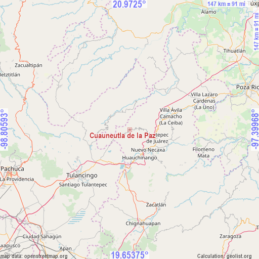
| Upper-left | 20.9725°, | -98.80593° |
| Center: | 20.31453°, | -98.1028° |
| Lower-right: | 19.65375°, | -97.39968° |
| Map W x H: | 146.6×146.6 km | = 91.1×91.1mi |
| max Lat: | 32.7° ⇑36.2% North |
| Cuauneutla de la Paz: | 20.31453° |
| min Lat: | ⇓63.8% South 14.53588° |
| min Long | Cuauneutla de l | max Long |
| -117.105° | -98.1028° | -86.73105° |
| W 62.5%⇐ | ⇒37.5% E |
Elevation
Elevation of Cuauneutla de la Paz is 1023 m = 3356 ft, and this is 230.7 m = 757 ft below average elevation for this country.
| Max E: |
3497 m = 11473 ft | 59.6% |
| Avg. | 1253.7 m = 4113 ft | |
| Cuauneutla de la Paz | 1023 m = 3356 ft | |
Min E: |
-1 m = -3 ft | 40.4% |
See also: Mexico elevation on elevation.city.
Geographical zone
Cuauneutla de la Paz is located in North Torrid zone (between Equator and Tropic of Cancer). Distance of this Northern Tropic circle is 347.2 km =215.7 mi to North.| Distance of | km | miles | from Cuauneutla de la Paz |
|---|---|---|---|
| North Pole | 7748.3 | 4814.6 | to North |
| Arctic Circle | 5142.4 | 3195.3 | to North |
| Tropic Cancer | 347.2 | 215.7 | to North |
| Equator | 2258.8 | 1403.6 | to South |


Nearby cities:
15 places around Cuauneutla de la Paz: (largest is in red/bold)
• Acalapa
1 km =0.6 mi,  90°
90°
• Atla
4.9 km =3 mi,  207°
207°
• Atlantongo
5.8 km =3.6 mi,  196°
196°
• Copila
5.1 km =3.2 mi,  155°
155°
• Cuautepec
6.9 km =4.3 mi,  66°
66°
• Cueyatla
3.2 km =2 mi,  141°
141°
• Paciotla
4.6 km =2.9 mi,  243°
243°
• Pahuatlán de Valle
6.4 km =4 mi,  230°
230°
• San Pablito
6.4 km =4 mi,  256°
256°
• Santa María
5.1 km =3.2 mi, 89°
• Tlacuilotepec
3.8 km =2.4 mi, 70°
• Tlalcruz de Libres
1.5 km =0.9 mi,  220°
220°
• Xochimilco
5.4 km =3.4 mi, 262°
• Xolotla
7 km =4.3 mi, 206°
• Zoyatla de Guerrero
3.1 km =1.9 mi, 242°
Sources, notices
• [Note1] Compared only with cities in Mexico existing in our database
• [Src1] Map data: © OpenStreetMap contributors (CC-BY-SA)
• [Src2] Other city data from geonames.org with taken over terms of usage.
• [Src3] Geographical zone / Annual Mean Temperature by Robert A. Rohde @ Wikipedia
