Copalillo geodata
Copalillo (Guerrero) is a seat of a second-order administrative division; located in Mexico in America/Mexico_City (GMT-6) time zone. With population of 6,910 people, there are 1349 cities with bigger population in this country. Compared to other cities in Mexico, 78.2% of cities are located further ↑North; 50.4% of cities are located further →East and 61.9% of cities have higher elevation than Copalillo. Note1


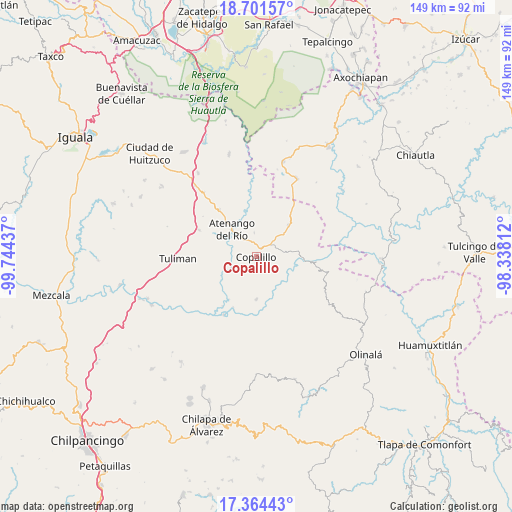
Copalillo GPS coordinates[2]
18° 2' 3.372" North, 99° 2' 28.464" West
| Map corner | latitude | longitude |
|---|---|---|
| Upper-left | 18.70157°, | -99.74437° |
| Center: | 18.03427°, | -99.04124° |
| Lower-right: | 17.36443°, | -98.33812° |
| Map W x H: | 148.7×148.7 km | = 92.4×92.4mi |
| max Lat: | 32.7° ⇑78.2% North |
| Copalillo: | 18.03427° |
| min Lat: | ⇓21.8% South 14.53588° |
| min Long | Copalillo | max Long |
| -117.105° | -99.04124° | -86.73105° |
| W 49.6%⇐ | ⇒50.4% E |
Elevation
Elevation of Copalillo is 886 m = 2907 ft, and this is 367.7 m = 1206 ft below average elevation for this country.
| Max E: |
3497 m = 11473 ft | 61.9% |
| Avg. | 1253.7 m = 4113 ft | |
| Copalillo | 886 m = 2907 ft | |
Min E: |
-1 m = -3 ft | 38.1% |
See also: Mexico elevation on elevation.city.
Geographical zone
Copalillo is located in North Torrid zone (between Equator and Tropic of Cancer). Distance of this Northern Tropic circle is 600.7 km =373.3 mi to North.| Distance of | km | miles | from Copalillo |
|---|---|---|---|
| North Pole | 8001.8 | 4972.1 | to North |
| Arctic Circle | 5396 | 3352.9 | to North |
| Tropic Cancer | 600.7 | 373.3 | to North |
| Equator | 2005.2 | 1246 | to South |


Nearby cities:
15 places around Copalillo: (largest is in red/bold)
• Apanguito
17.5 km =10.9 mi,  322°
322°
• Atenango del Río
10.6 km =6.6 mi, 318°
• El Cascalote
7 km =4.3 mi,  355°
355°
• Mezquitlán
11.3 km =7 mi,  97°
97°
• Mitlancingo
23.5 km =14.6 mi,  164°
164°
• Rincón de Cozahuapa
24.8 km =15.4 mi, 156°
• San Francisco Oxtutla
10 km =6.2 mi,  143°
143°
• San Juan (Las Joyas)
23.9 km =14.9 mi,  186°
186°
• Temalac de Morelos
13 km =8.1 mi,  45°
45°
• Tepetlapa
14.6 km =9.1 mi,  280°
280°
• Tepetlatipa
25.4 km =15.8 mi,  176°
176°
• Tequicuilco
18.3 km =11.4 mi,  295°
295°
• Tlalcozotitlán
19.3 km =12 mi,  209°
209°
• Tulimán
22.7 km =14.1 mi,  268°
268°
• Zicapa
12.4 km =7.7 mi, 179°
Sources, notices
• [Note1] Compared only with cities in Mexico existing in our database
• [Src1] Map data: © OpenStreetMap contributors (CC-BY-SA)
• [Src2] Other city data from geonames.org with taken over terms of usage.
• [Src3] Geographical zone / Annual Mean Temperature by Robert A. Rohde @ Wikipedia
