Mitlancingo geodata
Mitlancingo (Guerrero) is a populated place; located in Mexico in America/Mexico_City (GMT-6) time zone. With population of 755 people, there are 11595 cities with bigger population in this country. Compared to other cities in Mexico, 80.2% of cities are located further ↑North; 50.5% of cities are located further ←West and 64.8% of cities have higher elevation than Mitlancingo. Note1


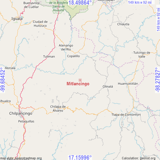
Mitlancingo GPS coordinates[2]
17° 49' 50.016" North, 98° 58' 53.004" West
| Map corner | latitude | longitude |
|---|---|---|
| Upper-left | 18.49864°, | -99.68452° |
| Center: | 17.83056°, | -98.98139° |
| Lower-right: | 17.15996°, | -98.27827° |
| Map W x H: | 148.8×148.8 km | = 92.5×92.5mi |
| max Lat: | 32.7° ⇑80.2% North |
| Mitlancingo: | 17.83056° |
| min Lat: | ⇓19.8% South 14.53588° |
| min Long | Mitlancingo | max Long |
| -117.105° | -98.98139° | -86.73105° |
| W 50.5%⇐ | ⇒49.5% E |
Elevation
Elevation of Mitlancingo is 700 m = 2297 ft, and this is 553.7 m = 1817 ft below average elevation for this country.
| Max E: |
3497 m = 11473 ft | 64.8% |
| Avg. | 1253.7 m = 4113 ft | |
| Mitlancingo | 700 m = 2297 ft | |
Min E: |
-1 m = -3 ft | 35.2% |
See also: Mexico elevation on elevation.city.
Geographical zone
Mitlancingo is located in North Torrid zone (between Equator and Tropic of Cancer). Distance of this Northern Tropic circle is 623.3 km =387.3 mi to North.| Distance of | km | miles | from Mitlancingo |
|---|---|---|---|
| North Pole | 8024.5 | 4986.2 | to North |
| Arctic Circle | 5418.6 | 3367 | to North |
| Tropic Cancer | 623.3 | 387.3 | to North |
| Equator | 1982.6 | 1231.9 | to South |


Nearby cities:
15 places around Mitlancingo: (largest is in red/bold)
• Ahuacuotzingo
13.8 km =8.6 mi,  159°
159°
• Ajuatetla
11.3 km =7 mi,  241°
241°
• Ostoyahualco
12.9 km =8 mi,  173°
173°
• Oztotitlán
18.2 km =11.3 mi,  194°
194°
• Rincón de Cozahuapa
3.4 km =2.1 mi,  93°
93°
• San Francisco Oxtutla
14.6 km =9.1 mi,  358°
358°
• San Juan (Las Joyas)
9.1 km =5.7 mi,  263°
263°
• Santa Catarina (Santa Catarina las Joyas)
14.7 km =9.1 mi,  232°
232°
• Tecolcuautla
6 km =3.7 mi,  144°
144°
• Tecozajca (Tepehuaje)
11.9 km =7.4 mi,  98°
98°
• Tepetlatipa
5.4 km =3.4 mi, 239°
• Tlalcomulco
14.9 km =9.3 mi,  204°
204°
• Tlalcozotitlán
16.9 km =10.5 mi,  290°
290°
• Xocoyolzintla
13.1 km =8.1 mi,  180°
180°
• Zicapa
12 km =7.5 mi,  328°
328°
Sources, notices
• [Note1] Compared only with cities in Mexico existing in our database
• [Src1] Map data: © OpenStreetMap contributors (CC-BY-SA)
• [Src2] Other city data from geonames.org with taken over terms of usage.
• [Src3] Geographical zone / Annual Mean Temperature by Robert A. Rohde @ Wikipedia
