Temalac de Morelos geodata
Temalac de Morelos (Guerrero) is a populated place; located in Mexico in America/Mexico_City (GMT-6) time zone. With population of 923 people, there are 9459 cities with bigger population in this country. Compared to other cities in Mexico, 77.3% of cities are located further ↑North; 51% of cities are located further ←West and 60.8% of cities have higher elevation than Temalac de Morelos. Note1


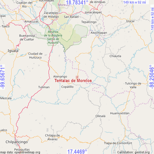
Temalac de Morelos GPS coordinates[2]
18° 6' 59.148" North, 98° 57' 12.888" West
| Map corner | latitude | longitude |
|---|---|---|
| Upper-left | 18.78341°, | -99.65671° |
| Center: | 18.11643°, | -98.95358° |
| Lower-right: | 17.4469°, | -98.25046° |
| Map W x H: | 148.6×148.6 km | = 92.3×92.3mi |
| max Lat: | 32.7° ⇑77.3% North |
| Temalac de Morelos: | 18.11643° |
| min Lat: | ⇓22.7% South 14.53588° |
| min Long | Temalac de More | max Long |
| -117.105° | -98.95358° | -86.73105° |
| W 51%⇐ | ⇒49% E |
Elevation
Elevation of Temalac de Morelos is 954 m = 3130 ft, and this is 299.7 m = 983 ft below average elevation for this country.
| Max E: |
3497 m = 11473 ft | 60.8% |
| Avg. | 1253.7 m = 4113 ft | |
| Temalac de Morelos | 954 m = 3130 ft | |
Min E: |
-1 m = -3 ft | 39.2% |
See also: Mexico elevation on elevation.city.
Geographical zone
Temalac de Morelos is located in North Torrid zone (between Equator and Tropic of Cancer). Distance of this Northern Tropic circle is 591.6 km =367.6 mi to North.| Distance of | km | miles | from Temalac de Morelos |
|---|---|---|---|
| North Pole | 7992.7 | 4966.4 | to North |
| Arctic Circle | 5386.8 | 3347.2 | to North |
| Tropic Cancer | 591.6 | 367.6 | to North |
| Equator | 2014.4 | 1251.7 | to South |


Nearby cities:
15 places around Temalac de Morelos: (largest is in red/bold)
• Apanguito
20.5 km =12.7 mi,  283°
283°
• Atenango del Río
16.3 km =10.1 mi,  265°
265°
• Ayoxuxtla
26.5 km =16.5 mi,  50°
50°
• Copalillo
13 km =8.1 mi,  225°
225°
• El Cascalote
10 km =6.2 mi,  257°
257°
• Huachinantla
18.4 km =11.4 mi,  355°
355°
• Jolalpan
25.9 km =16.1 mi,  26°
26°
• Mezquitlán
10.8 km =6.7 mi,  169°
169°
• San Francisco Oxtutla
17.5 km =10.9 mi,  190°
190°
• Santa Mónica
18.9 km =11.7 mi,  57°
57°
• Tepetlapa
24.5 km =15.2 mi,  254°
254°
• Tequicuilco
25.9 km =16.1 mi, 266°
• Teutla
19.3 km =12 mi,  1°
1°
• Xochitepec
14.9 km =9.3 mi, 33°
• Zicapa
23.4 km =14.5 mi,  203°
203°
Sources, notices
• [Note1] Compared only with cities in Mexico existing in our database
• [Src1] Map data: © OpenStreetMap contributors (CC-BY-SA)
• [Src2] Other city data from geonames.org with taken over terms of usage.
• [Src3] Geographical zone / Annual Mean Temperature by Robert A. Rohde @ Wikipedia
