Atenango del Río geodata
Atenango del Río (Guerrero) is a seat of a second-order administrative division; located in Mexico in America/Mexico_City (GMT-6) time zone. With population of 2,842 people, there are 3125 cities with bigger population in this country. Compared to other cities in Mexico, 77.5% of cities are located further ↑North; 51.3% of cities are located further →East and 66% of cities have higher elevation than Atenango del Río. Note1


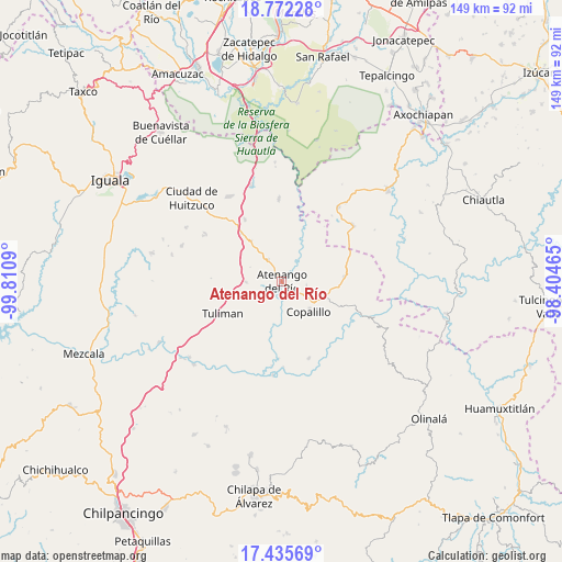
Atenango del Río GPS coordinates[2]
18° 6' 18.936" North, 99° 6' 27.972" West
| Map corner | latitude | longitude |
|---|---|---|
| Upper-left | 18.77228°, | -99.8109° |
| Center: | 18.10526°, | -99.10777° |
| Lower-right: | 17.43569°, | -98.40465° |
| Map W x H: | 148.6×148.6 km | = 92.3×92.3mi |
| max Lat: | 32.7° ⇑77.5% North |
| Atenango del Río: | 18.10526° |
| min Lat: | ⇓22.5% South 14.53588° |
| min Long | Atenango del R� | max Long |
| -117.105° | -99.10777° | -86.73105° |
| W 48.7%⇐ | ⇒51.3% E |
Elevation
Elevation of Atenango del Río is 635 m = 2083 ft, and this is 618.7 m = 2030 ft below average elevation for this country.
| Max E: |
3497 m = 11473 ft | 66% |
| Avg. | 1253.7 m = 4113 ft | |
| Atenango del Río | 635 m = 2083 ft | |
Min E: |
-1 m = -3 ft | 34% |
See also: Mexico elevation on elevation.city.
Geographical zone
Atenango del Río is located in North Torrid zone (between Equator and Tropic of Cancer). Distance of this Northern Tropic circle is 592.8 km =368.3 mi to North.| Distance of | km | miles | from Atenango del Río |
|---|---|---|---|
| North Pole | 7993.9 | 4967.2 | to North |
| Arctic Circle | 5388.1 | 3348 | to North |
| Tropic Cancer | 592.8 | 368.3 | to North |
| Equator | 2013.1 | 1250.9 | to South |


Nearby cities:
15 places around Atenango del Río: (largest is in red/bold)
• Apanguito
6.9 km =4.3 mi,  327°
327°
• Chaucingo
21.7 km =13.5 mi,  357°
357°
• Copalillo
10.6 km =6.6 mi,  138°
138°
• El Cascalote
6.6 km =4.1 mi,  97°
97°
• Huachinantla
24.6 km =15.3 mi,  36°
36°
• Lagunillas
23.6 km =14.7 mi,  301°
301°
• Mezquitlán
20.5 km =12.7 mi,  117°
117°
• Paso Morelos
16.8 km =10.4 mi,  320°
320°
• San Francisco Oxtutla
20.6 km =12.8 mi, 140°
• San Miguel de las Palmas
19.1 km =11.9 mi, 328°
• Temalac de Morelos
16.3 km =10.1 mi,  85°
85°
• Tepetlapa
9.1 km =5.7 mi,  233°
233°
• Tequicuilco
9.5 km =5.9 mi,  269°
269°
• Tulimán
17.8 km =11.1 mi,  241°
241°
• Zicapa
21.5 km =13.4 mi,  160°
160°
Sources, notices
• [Note1] Compared only with cities in Mexico existing in our database
• [Src1] Map data: © OpenStreetMap contributors (CC-BY-SA)
• [Src2] Other city data from geonames.org with taken over terms of usage.
• [Src3] Geographical zone / Annual Mean Temperature by Robert A. Rohde @ Wikipedia
