Apanguito geodata
Apanguito (Guerrero) is a populated place; located in Mexico in America/Mexico_City (GMT-6) time zone. With population of 612 people, there are 14088 cities with bigger population in this country. Compared to other cities in Mexico, 76.8% of cities are located further ↑North; 51.7% of cities are located further →East and 63.3% of cities have higher elevation than Apanguito. Note1


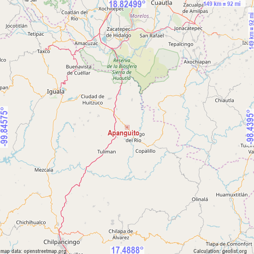
Apanguito GPS coordinates[2]
18° 9' 29.412" North, 99° 8' 33.432" West
| Map corner | latitude | longitude |
|---|---|---|
| Upper-left | 18.82499°, | -99.84575° |
| Center: | 18.15817°, | -99.14262° |
| Lower-right: | 17.4888°, | -98.4395° |
| Map W x H: | 148.6×148.6 km | = 92.3×92.3mi |
| max Lat: | 32.7° ⇑76.8% North |
| Apanguito: | 18.15817° |
| min Lat: | ⇓23.2% South 14.53588° |
| min Long | Apanguito | max Long |
| -117.105° | -99.14262° | -86.73105° |
| W 48.3%⇐ | ⇒51.7% E |
Elevation
Elevation of Apanguito is 797 m = 2615 ft, and this is 456.7 m = 1498 ft below average elevation for this country.
| Max E: |
3497 m = 11473 ft | 63.3% |
| Avg. | 1253.7 m = 4113 ft | |
| Apanguito | 797 m = 2615 ft | |
Min E: |
-1 m = -3 ft | 36.7% |
See also: Mexico elevation on elevation.city.
Geographical zone
Apanguito is located in North Torrid zone (between Equator and Tropic of Cancer). Distance of this Northern Tropic circle is 586.9 km =364.7 mi to North.| Distance of | km | miles | from Apanguito |
|---|---|---|---|
| North Pole | 7988.1 | 4963.6 | to North |
| Arctic Circle | 5382.2 | 3344.3 | to North |
| Tropic Cancer | 586.9 | 364.7 | to North |
| Equator | 2019 | 1254.5 | to South |


Nearby cities:
15 places around Apanguito: (largest is in red/bold)
• Atenango del Río
6.9 km =4.3 mi,  147°
147°
• Cacahuananche
23 km =14.3 mi,  279°
279°
• Chaucingo
16.1 km =10 mi,  10°
10°
• Copalillo
17.5 km =10.9 mi,  142°
142°
• El Cascalote
12.2 km =7.6 mi,  123°
123°
• Escuchapa
19.7 km =12.2 mi,  327°
327°
• Huachinantla
23 km =14.3 mi,  53°
53°
• Lagunillas
17.6 km =10.9 mi,  291°
291°
• Paso Morelos
10 km =6.2 mi,  314°
314°
• Quetzalapa
20.2 km =12.6 mi,  346°
346°
• San Miguel de las Palmas
12.1 km =7.5 mi, 329°
• Temalac de Morelos
20.5 km =12.7 mi,  103°
103°
• Tepetlapa
11.8 km =7.3 mi,  197°
197°
• Tequicuilco
8.4 km =5.2 mi,  224°
224°
• Tulimán
18.7 km =11.6 mi, 219°
Sources, notices
• [Note1] Compared only with cities in Mexico existing in our database
• [Src1] Map data: © OpenStreetMap contributors (CC-BY-SA)
• [Src2] Other city data from geonames.org with taken over terms of usage.
• [Src3] Geographical zone / Annual Mean Temperature by Robert A. Rohde @ Wikipedia
