La Laguna geodata
La Laguna (Veracruz) is a populated place; located in Mexico in America/Mexico_City (GMT-6) time zone. With population of 668 people, there are 12987 cities with bigger population in this country. Compared to other cities in Mexico, 66.6% of cities are located further ↓South; 70.1% of cities are located further ←West and 79.2% of cities have higher elevation than La Laguna. Note1


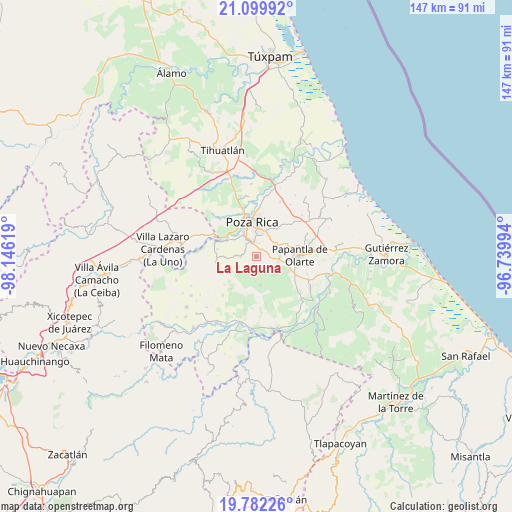
La Laguna GPS coordinates[2]
20° 26' 33" North, 97° 26' 35.016" West
| Map corner | latitude | longitude |
|---|---|---|
| Upper-left | 21.09992°, | -98.14619° |
| Center: | 20.4425°, | -97.44306° |
| Lower-right: | 19.78226°, | -96.73994° |
| Map W x H: | 146.5×146.5 km | = 91×91mi |
| max Lat: | 32.7° ⇑33.4% North |
| La Laguna: | 20.4425° |
| min Lat: | ⇓66.6% South 14.53588° |
| min Long | La Laguna | max Long |
| -117.105° | -97.44306° | -86.73105° |
| W 70.1%⇐ | ⇒29.9% E |
Elevation
Elevation of La Laguna is 107 m = 351 ft, and this is 1146.7 m = 3762 ft below average elevation for this country.
| Max E: |
3497 m = 11473 ft | 79.2% |
| Avg. | 1253.7 m = 4113 ft | |
| La Laguna | 107 m = 351 ft | |
Min E: |
-1 m = -3 ft | 20.8% |
See also: Mexico elevation on elevation.city.
Geographical zone
La Laguna is located in North Torrid zone (between Equator and Tropic of Cancer). Distance of this Northern Tropic circle is 332.9 km =206.9 mi to North.| Distance of | km | miles | from La Laguna |
|---|---|---|---|
| North Pole | 7734.1 | 4805.7 | to North |
| Arctic Circle | 5128.2 | 3186.5 | to North |
| Tropic Cancer | 332.9 | 206.9 | to North |
| Equator | 2273 | 1412.4 | to South |


Nearby cities:
15 places around La Laguna: (largest is in red/bold)
• Coatzintla
5.6 km =3.5 mi,  332°
332°
• Congregación el Tajín
6.5 km =4 mi,  101°
101°
• Corralillos
9.7 km =6 mi,  297°
297°
• Escolín de Olarte
6.5 km =4 mi,  18°
18°
• Gildardo Muñoz
7.5 km =4.7 mi,  134°
134°
• La Laja
7.7 km =4.8 mi,  307°
307°
• Manuel María Contreras
4.2 km =2.6 mi,  275°
275°
• Plan de Hidalgo
4.7 km =2.9 mi,  177°
177°
• Plan del Palmar
4.1 km =2.5 mi,  198°
198°
• Poza Rica de Hidalgo
10.2 km =6.3 mi,  350°
350°
• Reforma Escolín
7.7 km =4.8 mi,  50°
50°
• Ricardo Flores Magón
9.7 km =6 mi, 325°
• Tlahuanapa
9 km =5.6 mi,  111°
111°
• Troncones y Potrerillos
4.9 km =3 mi,  322°
322°
• Vista Hermosa de Madero
8 km =5 mi,  171°
171°
Sources, notices
• [Note1] Compared only with cities in Mexico existing in our database
• [Src1] Map data: © OpenStreetMap contributors (CC-BY-SA)
• [Src2] Other city data from geonames.org with taken over terms of usage.
• [Src3] Geographical zone / Annual Mean Temperature by Robert A. Rohde @ Wikipedia
