Citlaltépec geodata
Citlaltépec (Veracruz) is a seat of a second-order administrative division; located in Mexico in America/Mexico_City (GMT-6) time zone. With population of 5,005 people, there are 1845 cities with bigger population in this country. Compared to other cities in Mexico, 80.3% of cities are located further ↓South; 65.1% of cities are located further ←West and 74.7% of cities have higher elevation than Citlaltépec. Note1


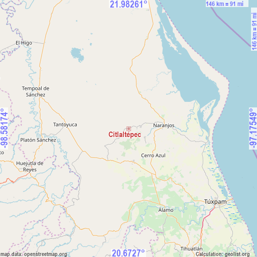
Citlaltépec GPS coordinates[2]
21° 19' 44.832" North, 97° 52' 42.996" West
| Map corner | latitude | longitude |
|---|---|---|
| Upper-left | 21.98261°, | -98.58174° |
| Center: | 21.32912°, | -97.87861° |
| Lower-right: | 20.6727°, | -97.17549° |
| Map W x H: | 145.6×145.7 km | = 90.5×90.5mi |
| max Lat: | 32.7° ⇑19.7% North |
| Citlaltépec: | 21.32912° |
| min Lat: | ⇓80.3% South 14.53588° |
| min Long | Citlaltépec | max Long |
| -117.105° | -97.87861° | -86.73105° |
| W 65.1%⇐ | ⇒34.9% E |
Elevation
Elevation of Citlaltépec is 231 m = 758 ft, and this is 1022.7 m = 3355 ft below average elevation for this country.
| Max E: |
3497 m = 11473 ft | 74.7% |
| Avg. | 1253.7 m = 4113 ft | |
| Citlaltépec | 231 m = 758 ft | |
Min E: |
-1 m = -3 ft | 25.3% |
See also: Mexico elevation on elevation.city.
Geographical zone
Citlaltépec is located in North Torrid zone (between Equator and Tropic of Cancer). Distance of this Northern Tropic circle is 234.3 km =145.6 mi to North.| Distance of | km | miles | from Citlaltépec |
|---|---|---|---|
| North Pole | 7635.5 | 4744.5 | to North |
| Arctic Circle | 5029.6 | 3125.2 | to North |
| Tropic Cancer | 234.3 | 145.6 | to North |
| Equator | 2371.6 | 1473.6 | to South |


Nearby cities:
15 places around Citlaltépec: (largest is in red/bold)
• Amatlán
12.6 km =7.8 mi,  86°
86°
• Carmona y Valle
9.3 km =5.8 mi,  67°
67°
• Chontla
6 km =3.7 mi,  231°
231°
• Cruz Manantial
9.9 km =6.2 mi,  267°
267°
• El Naranjal
1.4 km =0.9 mi,  292°
292°
• Gutiérrez Zamora
9.4 km =5.8 mi,  62°
62°
• La Garita
4.5 km =2.8 mi,  249°
249°
• Las Cruces
10.8 km =6.7 mi,  223°
223°
• Las Sabinas
1.3 km =0.8 mi,  190°
190°
• Mata de Otate
11.3 km =7 mi,  280°
280°
• Rancho Nuevo
4.2 km =2.6 mi,  327°
327°
• San Francisco
8.9 km =5.5 mi,  239°
239°
• Tamalín
7 km =4.3 mi,  80°
80°
• Tancoco
10.2 km =6.3 mi,  117°
117°
• Tantima
4.7 km =2.9 mi, 85°
Sources, notices
• [Note1] Compared only with cities in Mexico existing in our database
• [Src1] Map data: © OpenStreetMap contributors (CC-BY-SA)
• [Src2] Other city data from geonames.org with taken over terms of usage.
• [Src3] Geographical zone / Annual Mean Temperature by Robert A. Rohde @ Wikipedia
