Pixoy geodata
Pixoy (Yucatán) is a populated place; located in Mexico in America/Merida (GMT-6) time zone. With population of 1,054 people, there are 8280 cities with bigger population in this country. Compared to other cities in Mexico, 72% of cities are located further ↓South; 99.5% of cities are located further ←West and 88.3% of cities have higher elevation than Pixoy. Note1


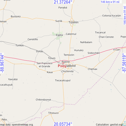
Pixoy GPS coordinates[2]
20° 42' 59.112" North, 88° 15' 51.516" West
| Map corner | latitude | longitude |
|---|---|---|
| Upper-left | 21.37264°, | -88.96744° |
| Center: | 20.71642°, | -88.26431° |
| Lower-right: | 20.05734°, | -87.56119° |
| Map W x H: | 146.2×146.3 km | = 90.8×90.9mi |
| max Lat: | 32.7° ⇑28% North |
| Pixoy: | 20.71642° |
| min Lat: | ⇓72% South 14.53588° |
| min Long | Pixoy | max Long |
| -117.105° | -88.26431° | -86.73105° |
| W 99.5%⇐ | ⇒0.5% E |
Elevation
Elevation of Pixoy is 29 m = 95 ft, and this is 1224.7 m = 4018 ft below average elevation for this country.
| Max E: |
3497 m = 11473 ft | 88.3% |
| Avg. | 1253.7 m = 4113 ft | |
| Pixoy | 29 m = 95 ft | |
Min E: |
-1 m = -3 ft | 11.7% |
See also: Mexico elevation on elevation.city.
Geographical zone
Pixoy is located in North Torrid zone (between Equator and Tropic of Cancer). Distance of this Northern Tropic circle is 302.5 km =188 mi to North.| Distance of | km | miles | from Pixoy |
|---|---|---|---|
| North Pole | 7703.6 | 4786.8 | to North |
| Arctic Circle | 5097.7 | 3167.6 | to North |
| Tropic Cancer | 302.5 | 188 | to North |
| Equator | 2303.4 | 1431.3 | to South |


Nearby cities:
15 places around Pixoy: (largest is in red/bold)
• Chichimila
10.6 km =6.6 mi,  152°
152°
• Cuncunul
9.1 km =5.7 mi,  202°
202°
• Dzitnup
8 km =5 mi,  165°
165°
• Ebtun
5.8 km =3.6 mi,  175°
175°
• Popola
3.4 km =2.1 mi,  56°
56°
• Tahmuy
13.6 km =8.5 mi,  69°
69°
• Tekom
12.6 km =7.8 mi, 180°
• Temozon
11.7 km =7.3 mi,  33°
33°
• Tesoco
11.4 km =7.1 mi,  86°
86°
• Tikuch
15.8 km =9.8 mi,  95°
95°
• Tinum
14.4 km =8.9 mi,  293°
293°
• Tixhualactún
15 km =9.3 mi,  122°
122°
• Uayma
5.5 km =3.4 mi,  271°
271°
• Valladolid
7.5 km =4.7 mi,  114°
114°
• Xocen
16.8 km =10.4 mi,  141°
141°
Sources, notices
• [Note1] Compared only with cities in Mexico existing in our database
• [Src1] Map data: © OpenStreetMap contributors (CC-BY-SA)
• [Src2] Other city data from geonames.org with taken over terms of usage.
• [Src3] Geographical zone / Annual Mean Temperature by Robert A. Rohde @ Wikipedia
