Ebtun geodata
Ebtun (Yucatán) is a populated place; located in Mexico in America/Merida (GMT-6) time zone. With population of 966 people, there are 9007 cities with bigger population in this country. Compared to other cities in Mexico, 71.1% of cities are located further ↓South; 99.5% of cities are located further ←West and 89.4% of cities have higher elevation than Ebtun. Note1


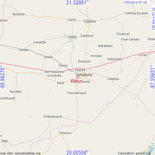
Ebtun GPS coordinates[2]
20° 39' 51.696" North, 88° 15' 34.668" West
| Map corner | latitude | longitude |
|---|---|---|
| Upper-left | 21.32081°, | -88.96276° |
| Center: | 20.66436°, | -88.25963° |
| Lower-right: | 20.00506°, | -87.55651° |
| Map W x H: | 146.3×146.3 km | = 90.9×90.9mi |
| max Lat: | 32.7° ⇑28.9% North |
| Ebtun: | 20.66436° |
| min Lat: | ⇓71.1% South 14.53588° |
| min Long | Ebtun | max Long |
| -117.105° | -88.25963° | -86.73105° |
| W 99.5%⇐ | ⇒0.5% E |
Elevation
Elevation of Ebtun is 26 m = 85 ft, and this is 1227.7 m = 4028 ft below average elevation for this country.
| Max E: |
3497 m = 11473 ft | 89.4% |
| Avg. | 1253.7 m = 4113 ft | |
| Ebtun | 26 m = 85 ft | |
Min E: |
-1 m = -3 ft | 10.6% |
See also: Mexico elevation on elevation.city.
Geographical zone
Ebtun is located in North Torrid zone (between Equator and Tropic of Cancer). Distance of this Northern Tropic circle is 308.3 km =191.6 mi to North.| Distance of | km | miles | from Ebtun |
|---|---|---|---|
| North Pole | 7709.4 | 4790.4 | to North |
| Arctic Circle | 5103.5 | 3171.2 | to North |
| Tropic Cancer | 308.3 | 191.6 | to North |
| Equator | 2297.7 | 1427.7 | to South |


Nearby cities:
15 places around Ebtun: (largest is in red/bold)
• Chichimila
5.7 km =3.5 mi,  129°
129°
• Cuncunul
4.7 km =2.9 mi,  236°
236°
• Dzitnup
2.5 km =1.6 mi,  140°
140°
• Pixoy
5.8 km =3.6 mi,  355°
355°
• Popola
8 km =5 mi,  16°
16°
• Tahmuy
16.2 km =10.1 mi,  49°
49°
• Tekom
6.8 km =4.2 mi,  184°
184°
• Temozon
16.7 km =10.4 mi, 21°
• Tesoco
12.7 km =7.9 mi,  59°
59°
• Tikuch
15.9 km =9.9 mi,  74°
74°
• Tixcacalcupul
14.3 km =8.9 mi, 184°
• Tixhualactún
12.3 km =7.6 mi,  100°
100°
• Uayma
8.4 km =5.2 mi,  314°
314°
• Valladolid
6.8 km =4.2 mi, 67°
• Xocen
12.4 km =7.7 mi, 126°
Sources, notices
• [Note1] Compared only with cities in Mexico existing in our database
• [Src1] Map data: © OpenStreetMap contributors (CC-BY-SA)
• [Src2] Other city data from geonames.org with taken over terms of usage.
• [Src3] Geographical zone / Annual Mean Temperature by Robert A. Rohde @ Wikipedia
