Uayma geodata
Uayma (Yucatán) is a populated place; located in Mexico in America/Merida (GMT-6) time zone. With population of 3,126 people, there are 2889 cities with bigger population in this country. Compared to other cities in Mexico, 72% of cities are located further ↓South; 99.4% of cities are located further ←West and 89.4% of cities have higher elevation than Uayma. Note1


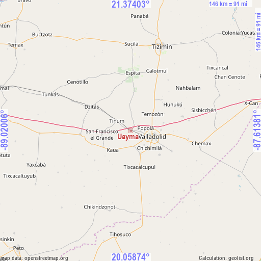
Uayma GPS coordinates[2]
20° 43' 4.116" North, 88° 19' 0.948" West
| Map corner | latitude | longitude |
|---|---|---|
| Upper-left | 21.37403°, | -89.02006° |
| Center: | 20.71781°, | -88.31693° |
| Lower-right: | 20.05874°, | -87.61381° |
| Map W x H: | 146.2×146.2 km | = 90.8×90.8mi |
| max Lat: | 32.7° ⇑28% North |
| Uayma: | 20.71781° |
| min Lat: | ⇓72% South 14.53588° |
| min Long | Uayma | max Long |
| -117.105° | -88.31693° | -86.73105° |
| W 99.4%⇐ | ⇒0.59999999999999% E |
Elevation
Elevation of Uayma is 26 m = 85 ft, and this is 1227.7 m = 4028 ft below average elevation for this country.
| Max E: |
3497 m = 11473 ft | 89.4% |
| Avg. | 1253.7 m = 4113 ft | |
| Uayma | 26 m = 85 ft | |
Min E: |
-1 m = -3 ft | 10.6% |
See also: Mexico elevation on elevation.city.
Geographical zone
Uayma is located in North Torrid zone (between Equator and Tropic of Cancer). Distance of this Northern Tropic circle is 302.3 km =187.8 mi to North.| Distance of | km | miles | from Uayma |
|---|---|---|---|
| North Pole | 7703.5 | 4786.7 | to North |
| Arctic Circle | 5097.6 | 3167.5 | to North |
| Tropic Cancer | 302.3 | 187.8 | to North |
| Equator | 2303.6 | 1431.4 | to South |


Nearby cities:
15 places around Uayma: (largest is in red/bold)
• Chichimila
14.1 km =8.8 mi,  132°
132°
• Cuncunul
8.8 km =5.5 mi,  166°
166°
• Dzitnup
10.9 km =6.8 mi,  136°
136°
• Ebtun
8.4 km =5.2 mi, 134°
• Kaua
14.8 km =9.2 mi,  223°
223°
• Pixoy
5.5 km =3.4 mi,  91°
91°
• Popola
8.4 km =5.2 mi,  78°
78°
• San Francisco Grande
16.4 km =10.2 mi,  263°
263°
• Tahmuy
18.8 km =11.7 mi, 75°
• Tekom
13.9 km =8.6 mi,  157°
157°
• Temozon
15.3 km =9.5 mi,  51°
51°
• Tesoco
16.9 km =10.5 mi, 88°
• Tinum
9.6 km =6 mi,  305°
305°
• Tohopkú
16.9 km =10.5 mi,  245°
245°
• Valladolid
12.7 km =7.9 mi,  105°
105°
Sources, notices
• [Note1] Compared only with cities in Mexico existing in our database
• [Src1] Map data: © OpenStreetMap contributors (CC-BY-SA)
• [Src2] Other city data from geonames.org with taken over terms of usage.
• [Src3] Geographical zone / Annual Mean Temperature by Robert A. Rohde @ Wikipedia
