Chacalapa geodata
Chacalapa (Veracruz) is a populated place; located in Mexico in America/Mexico_City (GMT-6) time zone. With population of 2,298 people, there are 3838 cities with bigger population in this country. Compared to other cities in Mexico, 77.8% of cities are located further ↑North; 85.2% of cities are located further ←West and 89.4% of cities have higher elevation than Chacalapa. Note1


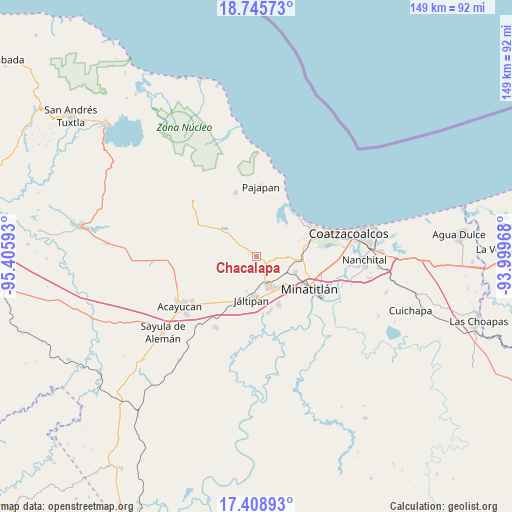
Chacalapa GPS coordinates[2]
18° 4' 42.96" North, 94° 42' 10.08" West
| Map corner | latitude | longitude |
|---|---|---|
| Upper-left | 18.74573°, | -95.40593° |
| Center: | 18.0786°, | -94.7028° |
| Lower-right: | 17.40893°, | -93.99968° |
| Map W x H: | 148.6×148.6 km | = 92.3×92.3mi |
| max Lat: | 32.7° ⇑77.8% North |
| Chacalapa: | 18.0786° |
| min Lat: | ⇓22.2% South 14.53588° |
| min Long | Chacalapa | max Long |
| -117.105° | -94.7028° | -86.73105° |
| W 85.2%⇐ | ⇒14.8% E |
Elevation
Elevation of Chacalapa is 26 m = 85 ft, and this is 1227.7 m = 4028 ft below average elevation for this country.
| Max E: |
3497 m = 11473 ft | 89.4% |
| Avg. | 1253.7 m = 4113 ft | |
| Chacalapa | 26 m = 85 ft | |
Min E: |
-1 m = -3 ft | 10.6% |
See also: Mexico elevation on elevation.city.
Geographical zone
Chacalapa is located in North Torrid zone (between Equator and Tropic of Cancer). Distance of this Northern Tropic circle is 595.8 km =370.2 mi to North.| Distance of | km | miles | from Chacalapa |
|---|---|---|---|
| North Pole | 7996.9 | 4969 | to North |
| Arctic Circle | 5391 | 3349.8 | to North |
| Tropic Cancer | 595.8 | 370.2 | to North |
| Equator | 2010.2 | 1249.1 | to South |


Nearby cities:
15 places around Chacalapa: (largest is in red/bold)
• Agua Fría
4.9 km =3 mi,  237°
237°
• Barrancas
12.3 km =7.6 mi,  94°
94°
• Chalcomulco
10.7 km =6.6 mi,  231°
231°
• Chinameca
6.8 km =4.2 mi,  158°
158°
• Cosoleacaque
11.3 km =7 mi,  141°
141°
• El Naranjo
9.8 km =6.1 mi,  311°
311°
• Hermenegildo J. Aldana
12.5 km =7.8 mi,  130°
130°
• José F. Gutiérrez
11.4 km =7.1 mi,  121°
121°
• Jáltipan de Morelos
12.6 km =7.8 mi,  185°
185°
• La Esperanza
11.9 km =7.4 mi, 119°
• Las Jacarandas
12.9 km =8 mi, 130°
• Los Cerritos
9.1 km =5.7 mi, 89°
• Minzapan
7.2 km =4.5 mi,  338°
338°
• Oteapan
9.4 km =5.8 mi, 155°
• Tonalapa
12.3 km =7.6 mi, 309°
Sources, notices
• [Note1] Compared only with cities in Mexico existing in our database
• [Src1] Map data: © OpenStreetMap contributors (CC-BY-SA)
• [Src2] Other city data from geonames.org with taken over terms of usage.
• [Src3] Geographical zone / Annual Mean Temperature by Robert A. Rohde @ Wikipedia
