Agua Fría geodata
Agua Fría (Veracruz) is a populated place; located in Mexico in America/Mexico_City (GMT-6) time zone. With population of 544 people, there are 15626 cities with bigger population in this country. Compared to other cities in Mexico, 78.1% of cities are located further ↑North; 85.1% of cities are located further ←West and 87.7% of cities have higher elevation than Agua Fría. Note1


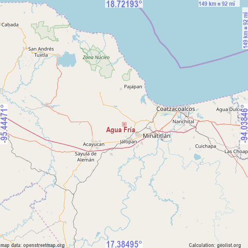
Agua Fría GPS coordinates[2]
18° 3' 16.956" North, 94° 44' 29.688" West
| Map corner | latitude | longitude |
|---|---|---|
| Upper-left | 18.72193°, | -95.44471° |
| Center: | 18.05471°, | -94.74158° |
| Lower-right: | 17.38495°, | -94.03846° |
| Map W x H: | 148.7×148.7 km | = 92.4×92.4mi |
| max Lat: | 32.7° ⇑78.1% North |
| Agua Fría: | 18.05471° |
| min Lat: | ⇓21.9% South 14.53588° |
| min Long | Agua Fría | max Long |
| -117.105° | -94.74158° | -86.73105° |
| W 85.1%⇐ | ⇒14.9% E |
Elevation
Elevation of Agua Fría is 31 m = 102 ft, and this is 1222.7 m = 4011 ft below average elevation for this country.
| Max E: |
3497 m = 11473 ft | 87.7% |
| Avg. | 1253.7 m = 4113 ft | |
| Agua Fría | 31 m = 102 ft | |
Min E: |
-1 m = -3 ft | 12.3% |
See also: Mexico elevation on elevation.city.
Geographical zone
Agua Fría is located in North Torrid zone (between Equator and Tropic of Cancer). Distance of this Northern Tropic circle is 598.4 km =371.8 mi to North.| Distance of | km | miles | from Agua Fría |
|---|---|---|---|
| North Pole | 7999.6 | 4970.7 | to North |
| Arctic Circle | 5393.7 | 3351.5 | to North |
| Tropic Cancer | 598.4 | 371.8 | to North |
| Equator | 2007.5 | 1247.4 | to South |


Nearby cities:
15 places around Agua Fría: (largest is in red/bold)
• Amamaloya
12.6 km =7.8 mi,  326°
326°
• Chacalapa
4.9 km =3 mi,  57°
57°
• Chalcomulco
5.9 km =3.7 mi,  227°
227°
• Chinameca
7.5 km =4.7 mi,  119°
119°
• Cosoleacaque
12.8 km =8 mi, 118°
• El Naranjo
9.7 km =6 mi,  340°
340°
• Fraccionamiento los Prados
13.8 km =8.6 mi,  128°
128°
• Hipólito Landeros (Zacatal)
13 km =8.1 mi,  216°
216°
• Huazuntlán
12.6 km =7.8 mi, 334°
• Jáltipan de Morelos
10.3 km =6.4 mi,  163°
163°
• Los Cerritos
13.5 km =8.4 mi,  78°
78°
• Minzapan
9.5 km =5.9 mi,  9°
9°
• Oteapan
9.9 km =6.2 mi, 126°
• San Andrés Chamilpa
12.6 km =7.8 mi,  289°
289°
• Tonalapa
11.8 km =7.3 mi, 332°
Sources, notices
• [Note1] Compared only with cities in Mexico existing in our database
• [Src1] Map data: © OpenStreetMap contributors (CC-BY-SA)
• [Src2] Other city data from geonames.org with taken over terms of usage.
• [Src3] Geographical zone / Annual Mean Temperature by Robert A. Rohde @ Wikipedia
