El Naranjo geodata
El Naranjo (Veracruz) is a populated place; located in Mexico in America/Mexico_City (GMT-6) time zone. With population of 644 people, there are 13427 cities with bigger population in this country. Compared to other cities in Mexico, 77.1% of cities are located further ↑North; 85.1% of cities are located further ←West and 84.1% of cities have higher elevation than El Naranjo. Note1


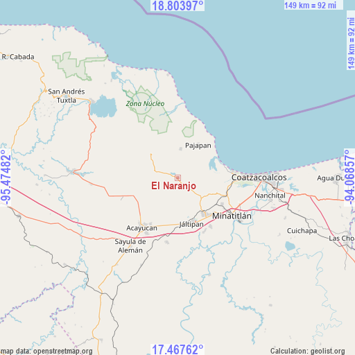
El Naranjo GPS coordinates[2]
18° 8' 13.452" North, 94° 46' 18.084" West
| Map corner | latitude | longitude |
|---|---|---|
| Upper-left | 18.80397°, | -95.47482° |
| Center: | 18.13707°, | -94.77169° |
| Lower-right: | 17.46762°, | -94.06857° |
| Map W x H: | 148.6×148.6 km | = 92.3×92.3mi |
| max Lat: | 32.7° ⇑77.1% North |
| El Naranjo: | 18.13707° |
| min Lat: | ⇓22.9% South 14.53588° |
| min Long | El Naranjo | max Long |
| -117.105° | -94.77169° | -86.73105° |
| W 85.1%⇐ | ⇒14.9% E |
Elevation
Elevation of El Naranjo is 51 m = 167 ft, and this is 1202.7 m = 3946 ft below average elevation for this country.
| Max E: |
3497 m = 11473 ft | 84.1% |
| Avg. | 1253.7 m = 4113 ft | |
| El Naranjo | 51 m = 167 ft | |
Min E: |
-1 m = -3 ft | 15.9% |
See also: Mexico elevation on elevation.city.
Geographical zone
El Naranjo is located in North Torrid zone (between Equator and Tropic of Cancer). Distance of this Northern Tropic circle is 589.3 km =366.2 mi to North.| Distance of | km | miles | from El Naranjo |
|---|---|---|---|
| North Pole | 7990.4 | 4965 | to North |
| Arctic Circle | 5384.5 | 3345.8 | to North |
| Tropic Cancer | 589.3 | 366.2 | to North |
| Equator | 2016.7 | 1253.1 | to South |


Nearby cities:
15 places around El Naranjo: (largest is in red/bold)
• Agua Fría
9.7 km =6 mi,  160°
160°
• Amamaloya
4.1 km =2.5 mi,  289°
289°
• Cerro de la Palma
7.4 km =4.6 mi, 293°
• Chacalapa
9.8 km =6.1 mi,  131°
131°
• Chalcomulco
13.2 km =8.2 mi,  185°
185°
• Huazuntlán
3.1 km =1.9 mi,  313°
313°
• Ixhuapán
5.2 km =3.2 mi,  326°
326°
• La Estribera
12.5 km =7.8 mi,  259°
259°
• Las Palomas (Bajo Paloma)
13.7 km =8.5 mi,  274°
274°
• Mecayapan
11.6 km =7.2 mi,  322°
322°
• Minzapan
4.7 km =2.9 mi,  87°
87°
• Saltillo
9 km =5.6 mi, 285°
• San Andrés Chamilpa
10 km =6.2 mi,  239°
239°
• Tatahuicapan
12.2 km =7.6 mi,  5°
5°
• Tonalapa
2.6 km =1.6 mi,  301°
301°
Sources, notices
• [Note1] Compared only with cities in Mexico existing in our database
• [Src1] Map data: © OpenStreetMap contributors (CC-BY-SA)
• [Src2] Other city data from geonames.org with taken over terms of usage.
• [Src3] Geographical zone / Annual Mean Temperature by Robert A. Rohde @ Wikipedia
