Chalcomulco geodata
Chalcomulco (Veracruz) is a populated place; located in Mexico in America/Mexico_City (GMT-6) time zone. With population of 796 people, there are 10956 cities with bigger population in this country. Compared to other cities in Mexico, 78.5% of cities are located further ↑North; 85% of cities are located further ←West and 83.3% of cities have higher elevation than Chalcomulco. Note1


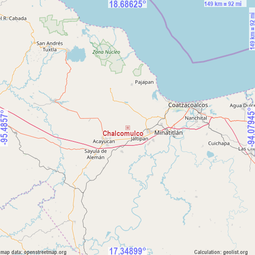
Chalcomulco GPS coordinates[2]
18° 1' 8.004" North, 94° 46' 57.252" West
| Map corner | latitude | longitude |
|---|---|---|
| Upper-left | 18.68625°, | -95.4857° |
| Center: | 18.01889°, | -94.78257° |
| Lower-right: | 17.34899°, | -94.07945° |
| Map W x H: | 148.7×148.7 km | = 92.4×92.4mi |
| max Lat: | 32.7° ⇑78.5% North |
| Chalcomulco: | 18.01889° |
| min Lat: | ⇓21.5% South 14.53588° |
| min Long | Chalcomulco | max Long |
| -117.105° | -94.78257° | -86.73105° |
| W 85%⇐ | ⇒15% E |
Elevation
Elevation of Chalcomulco is 58 m = 190 ft, and this is 1195.7 m = 3923 ft below average elevation for this country.
| Max E: |
3497 m = 11473 ft | 83.3% |
| Avg. | 1253.7 m = 4113 ft | |
| Chalcomulco | 58 m = 190 ft | |
Min E: |
-1 m = -3 ft | 16.7% |
See also: Mexico elevation on elevation.city.
Geographical zone
Chalcomulco is located in North Torrid zone (between Equator and Tropic of Cancer). Distance of this Northern Tropic circle is 602.4 km =374.3 mi to North.| Distance of | km | miles | from Chalcomulco |
|---|---|---|---|
| North Pole | 8003.5 | 4973.1 | to North |
| Arctic Circle | 5397.7 | 3354 | to North |
| Tropic Cancer | 602.4 | 374.3 | to North |
| Equator | 2003.5 | 1244.9 | to South |


Nearby cities:
15 places around Chalcomulco: (largest is in red/bold)
• Agua Fría
5.9 km =3.7 mi,  47°
47°
• Chacalapa
10.7 km =6.6 mi, 51°
• Chinameca
10.9 km =6.8 mi,  88°
88°
• Comején
11.9 km =7.4 mi,  293°
293°
• El Naranjo
13.2 km =8.2 mi,  5°
5°
• Fraccionamiento Santa Cruz
13 km =8.1 mi,  246°
246°
• Francisco I. Madero
10.3 km =6.4 mi,  222°
222°
• Hipólito Landeros (Zacatal)
7.3 km =4.5 mi,  207°
207°
• Ixhuapan
10 km =6.2 mi,  266°
266°
• Jáltipan de Morelos
9.4 km =5.8 mi,  129°
129°
• Monte Grande
12.1 km =7.5 mi, 286°
• Oteapan
12.5 km =7.8 mi,  98°
98°
• San Andrés Chamilpa
11.1 km =6.9 mi,  317°
317°
• Soconusco
12.1 km =7.5 mi,  239°
239°
• Tecuanapa
14 km =8.7 mi,  263°
263°
Sources, notices
• [Note1] Compared only with cities in Mexico existing in our database
• [Src1] Map data: © OpenStreetMap contributors (CC-BY-SA)
• [Src2] Other city data from geonames.org with taken over terms of usage.
• [Src3] Geographical zone / Annual Mean Temperature by Robert A. Rohde @ Wikipedia
