Candelaria Loxicha geodata
Candelaria Loxicha (Oaxaca) is a seat of a second-order administrative division; located in Mexico in America/Mexico_City (GMT-6) time zone. With population of 2,072 people, there are 4211 cities with bigger population in this country. Compared to other cities in Mexico, 97.5% of cities are located further ↑North; 79.7% of cities are located further ←West and 69.3% of cities have higher elevation than Candelaria Loxicha. Note1


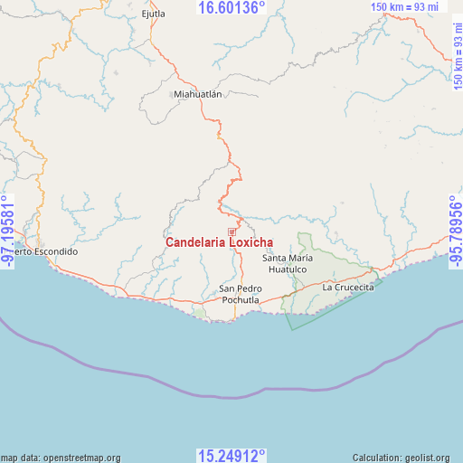
Candelaria Loxicha GPS coordinates[2]
15° 55' 34.968" North, 96° 29' 33.648" West
| Map corner | latitude | longitude |
|---|---|---|
| Upper-left | 16.60136°, | -97.19581° |
| Center: | 15.92638°, | -96.49268° |
| Lower-right: | 15.24912°, | -95.78956° |
| Map W x H: | 150.4×150.4 km | = 93.5×93.5mi |
| max Lat: | 32.7° ⇑97.5% North |
| Candelaria Loxicha: | 15.92638° |
| min Lat: | ⇓2.5% South 14.53588° |
| min Long | Candelaria Loxi | max Long |
| -117.105° | -96.49268° | -86.73105° |
| W 79.7%⇐ | ⇒20.3% E |
Elevation
Elevation of Candelaria Loxicha is 452 m = 1483 ft, and this is 801.7 m = 2630 ft below average elevation for this country.
| Max E: |
3497 m = 11473 ft | 69.3% |
| Avg. | 1253.7 m = 4113 ft | |
| Candelaria Loxicha | 452 m = 1483 ft | |
Min E: |
-1 m = -3 ft | 30.7% |
See also: Mexico elevation on elevation.city.
Geographical zone
Candelaria Loxicha is located in North Torrid zone (between Equator and Tropic of Cancer). Distance of this Northern Tropic circle is 835.1 km =518.9 mi to North.| Distance of | km | miles | from Candelaria Loxicha |
|---|---|---|---|
| North Pole | 8236.2 | 5117.7 | to North |
| Arctic Circle | 5630.3 | 3498.5 | to North |
| Tropic Cancer | 835.1 | 518.9 | to North |
| Equator | 1770.8 | 1100.3 | to South |


Nearby cities:
15 places around Candelaria Loxicha: (largest is in red/bold)
• Buenavista Loxicha
7 km =4.3 mi,  290°
290°
• Cerro Cantor
15 km =9.3 mi,  273°
273°
• El Camalote
15.2 km =9.4 mi,  246°
246°
• Los Horcones
13.5 km =8.4 mi,  221°
221°
• Los Naranjos Esquipulas
7.1 km =4.4 mi,  30°
30°
• Piedra del Sol
15.9 km =9.9 mi, 247°
• Pluma Hidalgo
7.9 km =4.9 mi,  89°
89°
• Reyes
12.2 km =7.6 mi,  177°
177°
• San Francisco Loxicha
13 km =8.1 mi,  260°
260°
• San José Chacalapa
11.2 km =7 mi,  164°
164°
• San José Piedras Negras
14.5 km =9 mi,  226°
226°
• San Pedro el Alto
12.3 km =7.6 mi,  9°
9°
• San Roque
15.8 km =9.8 mi,  168°
168°
• Santa María Tepejipana
4.2 km =2.6 mi,  244°
244°
• Toltepec
6.3 km =3.9 mi,  139°
139°
Sources, notices
• [Note1] Compared only with cities in Mexico existing in our database
• [Src1] Map data: © OpenStreetMap contributors (CC-BY-SA)
• [Src2] Other city data from geonames.org with taken over terms of usage.
• [Src3] Geographical zone / Annual Mean Temperature by Robert A. Rohde @ Wikipedia
