Pluma Hidalgo geodata
Pluma Hidalgo (Oaxaca) is a seat of a second-order administrative division; located in Mexico in America/Mexico_City (GMT-6) time zone. With population of 587 people, there are 14622 cities with bigger population in this country. Compared to other cities in Mexico, 97.5% of cities are located further ↑North; 80.1% of cities are located further ←West and 52.3% of cities have higher elevation than Pluma Hidalgo. Note1


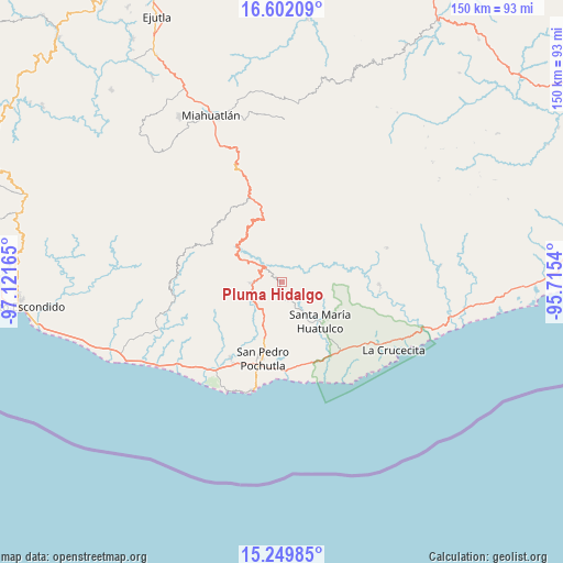
Pluma Hidalgo GPS coordinates[2]
15° 55' 37.596" North, 96° 25' 6.672" West
| Map corner | latitude | longitude |
|---|---|---|
| Upper-left | 16.60209°, | -97.12165° |
| Center: | 15.92711°, | -96.41852° |
| Lower-right: | 15.24985°, | -95.7154° |
| Map W x H: | 150.4×150.4 km | = 93.5×93.5mi |
| max Lat: | 32.7° ⇑97.5% North |
| Pluma Hidalgo: | 15.92711° |
| min Lat: | ⇓2.5% South 14.53588° |
| min Long | Pluma Hidalgo | max Long |
| -117.105° | -96.41852° | -86.73105° |
| W 80.1%⇐ | ⇒19.9% E |
Elevation
Elevation of Pluma Hidalgo is 1322 m = 4337 ft, and this is 68.3 m = 224 ft above average elevation for this country.
| Max E: |
3497 m = 11473 ft | 52.3% |
| Pluma Hidalgo | 1322 m 4337 ft | |
| Avg. | 1253.7 m = 4113 ft | |
Min E: |
-1 m = -3 ft | 47.7% |
See also: Mexico elevation on elevation.city.
Geographical zone
Pluma Hidalgo is located in North Torrid zone (between Equator and Tropic of Cancer). Distance of this Northern Tropic circle is 835 km =518.8 mi to North.| Distance of | km | miles | from Pluma Hidalgo |
|---|---|---|---|
| North Pole | 8236.1 | 5117.7 | to North |
| Arctic Circle | 5630.2 | 3498.4 | to North |
| Tropic Cancer | 835 | 518.8 | to North |
| Equator | 1770.9 | 1100.4 | to South |


Nearby cities:
15 places around Pluma Hidalgo: (largest is in red/bold)
• Benito Juárez
11.3 km =7 mi,  116°
116°
• Buenavista Loxicha
14.7 km =9.1 mi,  279°
279°
• Candelaria Loxicha
7.9 km =4.9 mi,  269°
269°
• La Erradura
13.7 km =8.5 mi,  139°
139°
• Los Naranjos Esquipulas
7.4 km =4.6 mi,  324°
324°
• Paso Ancho
14.4 km =8.9 mi,  130°
130°
• Reyes
14.3 km =8.9 mi,  210°
210°
• San Isidro Apango
14.6 km =9.1 mi,  153°
153°
• San José Chacalapa
11.9 km =7.4 mi,  204°
204°
• San Mateo Piñas
12.1 km =7.5 mi,  47°
47°
• San Pedro el Alto
13.4 km =8.3 mi,  333°
333°
• Santa María Huatulco
14.8 km =9.2 mi, 135°
• Santa María Limón
14.9 km =9.3 mi,  159°
159°
• Santa María Tepejipana
11.9 km =7.4 mi,  260°
260°
• Toltepec
6.2 km =3.9 mi,  218°
218°
Sources, notices
• [Note1] Compared only with cities in Mexico existing in our database
• [Src1] Map data: © OpenStreetMap contributors (CC-BY-SA)
• [Src2] Other city data from geonames.org with taken over terms of usage.
• [Src3] Geographical zone / Annual Mean Temperature by Robert A. Rohde @ Wikipedia
