Buena Vista geodata
Buena Vista (Veracruz) is a populated place; located in Mexico in America/Mexico_City (GMT-6) time zone. With population of 1,054 people, there are 8280 cities with bigger population in this country. Compared to other cities in Mexico, 64% of cities are located further ↑North; 76.6% of cities are located further ←West and 54.1% of cities have higher elevation than Buena Vista. Note1


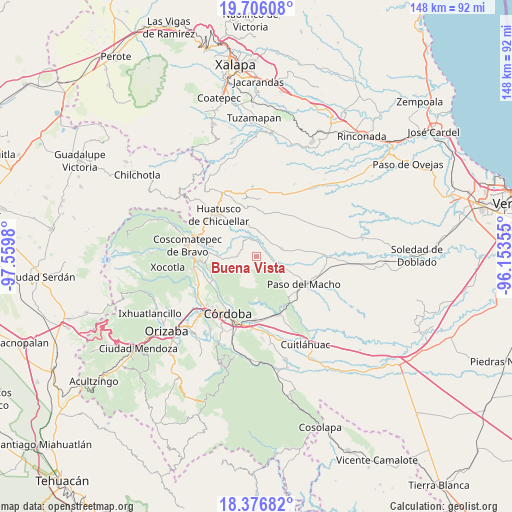
Buena Vista GPS coordinates[2]
19° 2' 34.008" North, 96° 51' 24.012" West
| Map corner | latitude | longitude |
|---|---|---|
| Upper-left | 19.70608°, | -97.5598° |
| Center: | 19.04278°, | -96.85667° |
| Lower-right: | 18.37682°, | -96.15355° |
| Map W x H: | 147.8×147.8 km | = 91.8×91.8mi |
| max Lat: | 32.7° ⇑64% North |
| Buena Vista: | 19.04278° |
| min Lat: | ⇓36% South 14.53588° |
| min Long | Buena Vista | max Long |
| -117.105° | -96.85667° | -86.73105° |
| W 76.6%⇐ | ⇒23.4% E |
Elevation
Elevation of Buena Vista is 1238 m = 4062 ft, and this is 15.7 m = 52 ft below average elevation for this country.
| Max E: |
3497 m = 11473 ft | 54.1% |
| Avg. | 1253.7 m = 4113 ft | |
| Buena Vista | 1238 m = 4062 ft | |
Min E: |
-1 m = -3 ft | 45.9% |
See also: Mexico elevation on elevation.city.
Geographical zone
Buena Vista is located in North Torrid zone (between Equator and Tropic of Cancer). Distance of this Northern Tropic circle is 488.6 km =303.6 mi to North.| Distance of | km | miles | from Buena Vista |
|---|---|---|---|
| North Pole | 7889.7 | 4902.4 | to North |
| Arctic Circle | 5283.8 | 3283.2 | to North |
| Tropic Cancer | 488.6 | 303.6 | to North |
| Equator | 2117.4 | 1315.7 | to South |


Nearby cities:
15 places around Buena Vista: (largest is in red/bold)
• Agua Escondida (El Olvido)
6 km =3.7 mi,  38°
38°
• Capulapa
7.1 km =4.4 mi,  332°
332°
• Cerro Azul
7.5 km =4.7 mi,  125°
125°
• Corazón de Jesús (Piña)
4.4 km =2.7 mi,  52°
52°
• El Triunfo
3.6 km =2.2 mi,  336°
336°
• Ixcatla
7.5 km =4.7 mi,  298°
298°
• La Palma
3.1 km =1.9 mi,  84°
84°
• Ocotitlán
5.4 km =3.4 mi,  269°
269°
• Palo Gacho
5.4 km =3.4 mi,  108°
108°
• Progreso
5.6 km =3.5 mi,  148°
148°
• Puentecilla
5.9 km =3.7 mi,  6°
6°
• San José Tenejapa
3.3 km =2.1 mi, 154°
• Tepatlaxco
3.2 km =2 mi,  22°
22°
• Zacamitla
7.2 km =4.5 mi,  277°
277°
• Álvaro Obregón
4.2 km =2.6 mi,  198°
198°
Sources, notices
• [Note1] Compared only with cities in Mexico existing in our database
• [Src1] Map data: © OpenStreetMap contributors (CC-BY-SA)
• [Src2] Other city data from geonames.org with taken over terms of usage.
• [Src3] Geographical zone / Annual Mean Temperature by Robert A. Rohde @ Wikipedia
