Palo Gacho geodata
Palo Gacho (Veracruz) is a populated place; located in Mexico in America/Mexico_City (GMT-6) time zone. With population of 544 people, there are 15626 cities with bigger population in this country. Compared to other cities in Mexico, 64.2% of cities are located further ↑North; 77.1% of cities are located further ←West and 64.8% of cities have higher elevation than Palo Gacho. Note1


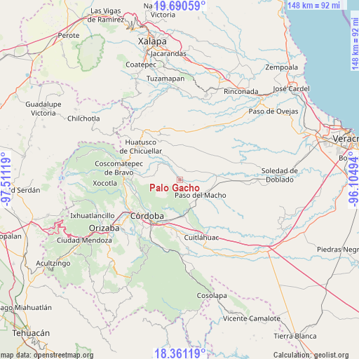
Palo Gacho GPS coordinates[2]
19° 1' 37.992" North, 96° 48' 29.016" West
| Map corner | latitude | longitude |
|---|---|---|
| Upper-left | 19.69059°, | -97.51119° |
| Center: | 19.02722°, | -96.80806° |
| Lower-right: | 18.36119°, | -96.10494° |
| Map W x H: | 147.8×147.8 km | = 91.8×91.8mi |
| max Lat: | 32.7° ⇑64.2% North |
| Palo Gacho: | 19.02722° |
| min Lat: | ⇓35.8% South 14.53588° |
| min Long | Palo Gacho | max Long |
| -117.105° | -96.80806° | -86.73105° |
| W 77.1%⇐ | ⇒22.9% E |
Elevation
Elevation of Palo Gacho is 696 m = 2283 ft, and this is 557.7 m = 1830 ft below average elevation for this country.
| Max E: |
3497 m = 11473 ft | 64.8% |
| Avg. | 1253.7 m = 4113 ft | |
| Palo Gacho | 696 m = 2283 ft | |
Min E: |
-1 m = -3 ft | 35.2% |
See also: Mexico elevation on elevation.city.
Geographical zone
Palo Gacho is located in North Torrid zone (between Equator and Tropic of Cancer). Distance of this Northern Tropic circle is 490.3 km =304.7 mi to North.| Distance of | km | miles | from Palo Gacho |
|---|---|---|---|
| North Pole | 7891.4 | 4903.5 | to North |
| Arctic Circle | 5285.5 | 3284.3 | to North |
| Tropic Cancer | 490.3 | 304.7 | to North |
| Equator | 2115.6 | 1314.6 | to South |


Nearby cities:
15 places around Palo Gacho: (largest is in red/bold)
• Agua Escondida (El Olvido)
6.5 km =4 mi,  348°
348°
• Buena Vista
5.4 km =3.4 mi,  288°
288°
• Cerro Azul
2.8 km =1.7 mi,  159°
159°
• Corazón de Jesús (Piña)
4.7 km =2.9 mi,  339°
339°
• Ejido la Piña (Maromilla)
2.6 km =1.6 mi,  86°
86°
• Ejido los Naranjos
8.5 km =5.3 mi,  218°
218°
• El Triunfo
8.2 km =5.1 mi,  307°
307°
• La Charca
6.6 km =4.1 mi,  182°
182°
• La Palma
2.9 km =1.8 mi, 314°
• Mata Naranjo
5.2 km =3.2 mi,  118°
118°
• Progreso
3.8 km =2.4 mi, 215°
• Pueblito de Matlaluca
4.7 km =2.9 mi,  27°
27°
• San José Tenejapa
3.9 km =2.4 mi,  250°
250°
• Tepatlaxco
6.1 km =3.8 mi,  320°
320°
• Álvaro Obregón
6.8 km =4.2 mi, 250°
Sources, notices
• [Note1] Compared only with cities in Mexico existing in our database
• [Src1] Map data: © OpenStreetMap contributors (CC-BY-SA)
• [Src2] Other city data from geonames.org with taken over terms of usage.
• [Src3] Geographical zone / Annual Mean Temperature by Robert A. Rohde @ Wikipedia
