Ixcatla geodata
Ixcatla (Veracruz) is a populated place; located in Mexico in America/Mexico_City (GMT-6) time zone. With population of 1,137 people, there are 7633 cities with bigger population in this country. Compared to other cities in Mexico, 63.4% of cities are located further ↑North; 75.9% of cities are located further ←West and 58.7% of cities have higher elevation than Ixcatla. Note1


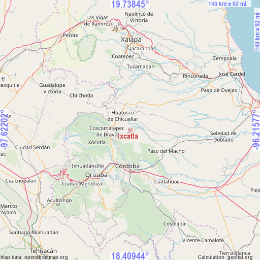
Ixcatla GPS coordinates[2]
19° 4' 31.008" North, 96° 55' 8.004" West
| Map corner | latitude | longitude |
|---|---|---|
| Upper-left | 19.73845°, | -97.62202° |
| Center: | 19.07528°, | -96.91889° |
| Lower-right: | 18.40944°, | -96.21577° |
| Map W x H: | 147.8×147.8 km | = 91.8×91.8mi |
| max Lat: | 32.7° ⇑63.4% North |
| Ixcatla: | 19.07528° |
| min Lat: | ⇓36.6% South 14.53588° |
| min Long | Ixcatla | max Long |
| -117.105° | -96.91889° | -86.73105° |
| W 75.9%⇐ | ⇒24.1% E |
Elevation
Elevation of Ixcatla is 1067 m = 3501 ft, and this is 186.7 m = 613 ft below average elevation for this country.
| Max E: |
3497 m = 11473 ft | 58.7% |
| Avg. | 1253.7 m = 4113 ft | |
| Ixcatla | 1067 m = 3501 ft | |
Min E: |
-1 m = -3 ft | 41.3% |
See also: Mexico elevation on elevation.city.
Geographical zone
Ixcatla is located in North Torrid zone (between Equator and Tropic of Cancer). Distance of this Northern Tropic circle is 484.9 km =301.3 mi to North.| Distance of | km | miles | from Ixcatla |
|---|---|---|---|
| North Pole | 7886.1 | 4900.2 | to North |
| Arctic Circle | 5280.2 | 3281 | to North |
| Tropic Cancer | 484.9 | 301.3 | to North |
| Equator | 2121 | 1317.9 | to South |


Nearby cities:
15 places around Ixcatla: (largest is in red/bold)
• Alta Luz
3.5 km =2.2 mi,  289°
289°
• Amatiopa
4.9 km =3 mi,  328°
328°
• Buena Vista
7.5 km =4.7 mi,  118°
118°
• Capulapa
4.2 km =2.6 mi,  50°
50°
• El Triunfo
5.1 km =3.2 mi,  93°
93°
• Guzmantla
6.9 km =4.3 mi,  184°
184°
• Ixhuatlán del Café
7.3 km =4.5 mi,  248°
248°
• Ixpila
6.9 km =4.3 mi,  313°
313°
• Mesa del Rancho
6.6 km =4.1 mi, 331°
• Michapa
5 km =3.1 mi, 311°
• Ocotitlán
3.8 km =2.4 mi,  163°
163°
• Presidio
5.6 km =3.5 mi,  263°
263°
• Puentecilla
7.6 km =4.7 mi,  72°
72°
• Tlamatoca
2.8 km =1.7 mi,  316°
316°
• Zacamitla
2.8 km =1.7 mi,  191°
191°
Sources, notices
• [Note1] Compared only with cities in Mexico existing in our database
• [Src1] Map data: © OpenStreetMap contributors (CC-BY-SA)
• [Src2] Other city data from geonames.org with taken over terms of usage.
• [Src3] Geographical zone / Annual Mean Temperature by Robert A. Rohde @ Wikipedia
