Progreso geodata
Progreso (Veracruz) is a populated place; located in Mexico in America/Mexico_City (GMT-6) time zone. With population of 516 people, there are 16314 cities with bigger population in this country. Compared to other cities in Mexico, 64.7% of cities are located further ↑North; 76.9% of cities are located further ←West and 59.4% of cities have higher elevation than Progreso. Note1


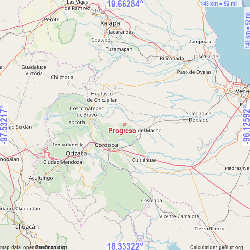
Progreso GPS coordinates[2]
18° 59' 57.696" North, 96° 49' 44.544" West
| Map corner | latitude | longitude |
|---|---|---|
| Upper-left | 19.66284°, | -97.53217° |
| Center: | 18.99936°, | -96.82904° |
| Lower-right: | 18.33322°, | -96.12592° |
| Map W x H: | 147.8×147.8 km | = 91.8×91.8mi |
| max Lat: | 32.7° ⇑64.7% North |
| Progreso: | 18.99936° |
| min Lat: | ⇓35.3% South 14.53588° |
| min Long | Progreso | max Long |
| -117.105° | -96.82904° | -86.73105° |
| W 76.9%⇐ | ⇒23.1% E |
Elevation
Elevation of Progreso is 1029 m = 3376 ft, and this is 224.7 m = 737 ft below average elevation for this country.
| Max E: |
3497 m = 11473 ft | 59.4% |
| Avg. | 1253.7 m = 4113 ft | |
| Progreso | 1029 m = 3376 ft | |
Min E: |
-1 m = -3 ft | 40.6% |
See also: Mexico elevation on elevation.city.
Geographical zone
Progreso is located in North Torrid zone (between Equator and Tropic of Cancer). Distance of this Northern Tropic circle is 493.4 km =306.6 mi to North.| Distance of | km | miles | from Progreso |
|---|---|---|---|
| North Pole | 7894.5 | 4905.4 | to North |
| Arctic Circle | 5288.6 | 3286.2 | to North |
| Tropic Cancer | 493.4 | 306.6 | to North |
| Equator | 2112.5 | 1312.6 | to South |


Nearby cities:
15 places around Progreso: (largest is in red/bold)
• Buena Vista
5.6 km =3.5 mi,  328°
328°
• Cañada Blanca
5.9 km =3.7 mi,  207°
207°
• Cerro Azul
3.2 km =2 mi,  81°
81°
• Corazón de Jesús (Piña)
7.5 km =4.7 mi,  4°
4°
• Ejido la Piña (Maromilla)
5.8 km =3.6 mi,  55°
55°
• Ejido los Naranjos
4.7 km =2.9 mi,  220°
220°
• La Charca
4.1 km =2.5 mi,  150°
150°
• La Palma
5.1 km =3.2 mi, 1°
• Mata Naranjo
6.8 km =4.2 mi, 84°
• Palo Gacho
3.8 km =2.4 mi,  35°
35°
• Plan de Ayala
6.7 km =4.2 mi,  233°
233°
• Pueblito de Matlaluca
8.5 km =5.3 mi,  31°
31°
• San José Tenejapa
2.3 km =1.4 mi,  320°
320°
• Tepatlaxco
7.9 km =4.9 mi,  347°
347°
• Álvaro Obregón
4.3 km =2.7 mi,  281°
281°
Sources, notices
• [Note1] Compared only with cities in Mexico existing in our database
• [Src1] Map data: © OpenStreetMap contributors (CC-BY-SA)
• [Src2] Other city data from geonames.org with taken over terms of usage.
• [Src3] Geographical zone / Annual Mean Temperature by Robert A. Rohde @ Wikipedia
