Linderos geodata
Linderos (Veracruz) is a populated place; located in Mexico in America/Mexico_City (GMT-6) time zone. With population of 600 people, there are 14337 cities with bigger population in this country. Compared to other cities in Mexico, 51.4% of cities are located further ↑North; 75.3% of cities are located further ←West and 56.8% of cities have lower elevation than Linderos. Note1


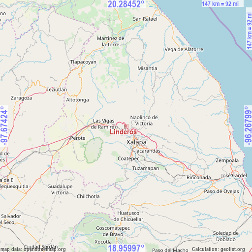
Linderos GPS coordinates[2]
19° 37' 24.996" North, 96° 58' 15.996" West
| Map corner | latitude | longitude |
|---|---|---|
| Upper-left | 20.28452°, | -97.67424° |
| Center: | 19.62361°, | -96.97111° |
| Lower-right: | 18.95997°, | -96.26799° |
| Map W x H: | 147.3×147.3 km | = 91.5×91.5mi |
| max Lat: | 32.7° ⇑51.4% North |
| Linderos: | 19.62361° |
| min Lat: | ⇓48.6% South 14.53588° |
| min Long | Linderos | max Long |
| -117.105° | -96.97111° | -86.73105° |
| W 75.3%⇐ | ⇒24.7% E |
Elevation
Elevation of Linderos is 1651 m = 5417 ft, and this is 397.3 m = 1303 ft above average elevation for this country.
| Max E: |
3497 m = 11473 ft | 43.2% |
| Linderos | 1651 m 5417 ft | |
| Avg. | 1253.7 m = 4113 ft | |
Min E: |
-1 m = -3 ft | 56.8% |
See also: Mexico elevation on elevation.city.
Geographical zone
Linderos is located in North Torrid zone (between Equator and Tropic of Cancer). Distance of this Northern Tropic circle is 424 km =263.5 mi to North.| Distance of | km | miles | from Linderos |
|---|---|---|---|
| North Pole | 7825.1 | 4862.3 | to North |
| Arctic Circle | 5219.2 | 3243.1 | to North |
| Tropic Cancer | 424 | 263.5 | to North |
| Equator | 2181.9 | 1355.8 | to South |


Nearby cities:
15 places around Linderos: (largest is in red/bold)
• Acajete
5.8 km =3.6 mi,  224°
224°
• Banderilla
5.2 km =3.2 mi,  137°
137°
• Coacoatzintla
4.5 km =2.8 mi,  45°
45°
• Duraznal
4.4 km =2.7 mi,  330°
330°
• El Fresno
2 km =1.2 mi,  322°
322°
• El Pueblito (Garbanzal)
5.9 km =3.7 mi,  123°
123°
• El Rosario
3.8 km =2.4 mi,  176°
176°
• Jilotepec
2.4 km =1.5 mi, 122°
• La Joya
6 km =3.7 mi,  256°
256°
• Las Lomas
6.3 km =3.9 mi,  90°
90°
• Piedra de Agua
2.3 km =1.4 mi,  158°
158°
• Piletas
4 km =2.5 mi,  191°
191°
• Rafael Lucio
3.9 km =2.4 mi,  210°
210°
• Tlacolulan
5.8 km =3.6 mi, 326°
• Xaltepec
4.8 km =3 mi, 123°
Sources, notices
• [Note1] Compared only with cities in Mexico existing in our database
• [Src1] Map data: © OpenStreetMap contributors (CC-BY-SA)
• [Src2] Other city data from geonames.org with taken over terms of usage.
• [Src3] Geographical zone / Annual Mean Temperature by Robert A. Rohde @ Wikipedia
