Azcapotzalco geodata
Azcapotzalco (Mexico City) is a populated place; located in Mexico in America/Mexico_City (GMT-6) time zone. With population of 414,711 people, there are 46 cities with bigger population in this country. Compared to other cities in Mexico, 54.3% of cities are located further ↑North; 52.5% of cities are located further →East and 84.3% of cities have lower elevation than Azcapotzalco. Note1


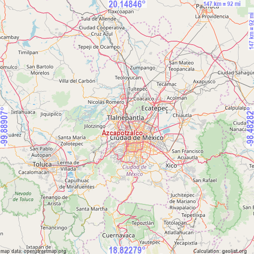
Azcapotzalco GPS coordinates[2]
19° 29' 13.128" North, 99° 11' 9.384" West
| Map corner | latitude | longitude |
|---|---|---|
| Upper-left | 20.14846°, | -99.88907° |
| Center: | 19.48698°, | -99.18594° |
| Lower-right: | 18.82279°, | -98.48282° |
| Map W x H: | 147.4×147.4 km | = 91.6×91.6mi |
| max Lat: | 32.7° ⇑54.3% North |
| Azcapotzalco: | 19.48698° |
| min Lat: | ⇓45.7% South 14.53588° |
| min Long | Azcapotzalco | max Long |
| -117.105° | -99.18594° | -86.73105° |
| W 47.5%⇐ | ⇒52.5% E |
Elevation
Elevation of Azcapotzalco is 2249 m = 7379 ft, and this is 995.3 m = 3265 ft above average elevation for this country.
| Max E: |
3497 m = 11473 ft | 15.7% |
| Azcapotzalco | 2249 m 7379 ft | |
| Avg. | 1253.7 m = 4113 ft | |
Min E: |
-1 m = -3 ft | 84.3% |
See also: Azcapotzalco elevation on elevation.city.
Geographical zone
Azcapotzalco is located in North Torrid zone (between Equator and Tropic of Cancer). Distance of this Northern Tropic circle is 439.2 km =272.9 mi to North.| Distance of | km | miles | from Azcapotzalco |
|---|---|---|---|
| North Pole | 7840.3 | 4871.7 | to North |
| Arctic Circle | 5234.4 | 3252.5 | to North |
| Tropic Cancer | 439.2 | 272.9 | to North |
| Equator | 2166.7 | 1346.3 | to South |


Nearby cities:
15 places around Azcapotzalco: (largest is in red/bold)
• Ampliación el Tejocote
10.9 km =6.8 mi,  268°
268°
• Benito Juarez
10.3 km =6.4 mi,  163°
163°
• Ciudad López Mateos
10.8 km =6.7 mi,  316°
316°
• Colonia Lindavista
6.4 km =4 mi,  85°
85°
• Cuauhtémoc
6.3 km =3.9 mi,  138°
138°
• Ejido del Tejocote
9.7 km =6 mi, 268°
• Gustavo Adolfo Madero
7.9 km =4.9 mi,  84°
84°
• Mexico City
8.9 km =5.5 mi, 136°
• Miguel Hidalgo
6.1 km =3.8 mi,  194°
194°
• Naucalpan de Juárez
5.7 km =3.5 mi,  260°
260°
• Polanco
6.1 km =3.8 mi, 193°
• Rincón Verde
11 km =6.8 mi,  275°
275°
• Tlalnepantla
6 km =3.7 mi,  350°
350°
• Venustiano Carranza
9.8 km =6.1 mi,  119°
119°
• Vista Hermosa
5.1 km =3.2 mi,  309°
309°
Sources, notices
• [Note1] Compared only with cities in Mexico existing in our database
• [Src1] Map data: © OpenStreetMap contributors (CC-BY-SA)
• [Src2] Other city data from geonames.org with taken over terms of usage.
• [Src3] Geographical zone / Annual Mean Temperature by Robert A. Rohde @ Wikipedia
