Miguel Hidalgo geodata
Miguel Hidalgo (Mexico City) is a populated place; located in Mexico in America/Mexico_City (GMT-6) time zone. With population of 372,889 people, there are 54 cities with bigger population in this country. Compared to other cities in Mexico, 55.4% of cities are located further ↑North; 52.8% of cities are located further →East and 85.4% of cities have lower elevation than Miguel Hidalgo. Note1


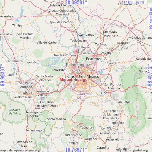
Miguel Hidalgo GPS coordinates[2]
19° 26' 2.796" North, 99° 12' 0.864" West
| Map corner | latitude | longitude |
|---|---|---|
| Upper-left | 20.09581°, | -99.90337° |
| Center: | 19.43411°, | -99.20024° |
| Lower-right: | 18.76971°, | -98.49712° |
| Map W x H: | 147.4×147.5 km | = 91.6×91.7mi |
| max Lat: | 32.7° ⇑55.4% North |
| Miguel Hidalgo: | 19.43411° |
| min Lat: | ⇓44.6% South 14.53588° |
| min Long | Miguel Hidalgo | max Long |
| -117.105° | -99.20024° | -86.73105° |
| W 47.2%⇐ | ⇒52.8% E |
Elevation
Elevation of Miguel Hidalgo is 2267 m = 7438 ft, and this is 1013.3 m = 3324 ft above average elevation for this country.
| Max E: |
3497 m = 11473 ft | 14.6% |
| Miguel Hidalgo | 2267 m 7438 ft | |
| Avg. | 1253.7 m = 4113 ft | |
Min E: |
-1 m = -3 ft | 85.4% |
See also: Miguel Hidalgo elevation on elevation.city.
Geographical zone
Miguel Hidalgo is located in North Torrid zone (between Equator and Tropic of Cancer). Distance of this Northern Tropic circle is 445 km =276.5 mi to North.| Distance of | km | miles | from Miguel Hidalgo |
|---|---|---|---|
| North Pole | 7846.2 | 4875.4 | to North |
| Arctic Circle | 5240.3 | 3256.2 | to North |
| Tropic Cancer | 445 | 276.5 | to North |
| Equator | 2160.9 | 1342.7 | to South |


Nearby cities:
15 places around Miguel Hidalgo: (largest is in red/bold)
• Azcapotzalco
6.1 km =3.8 mi,  14°
14°
• Benito Juarez
6 km =3.7 mi,  131°
131°
• Benito Juárez
8.2 km =5.1 mi,  146°
146°
• Col. Bosques de las Lomas
9.2 km =5.7 mi,  228°
228°
• Colonia Lindavista
10.2 km =6.3 mi,  51°
51°
• Colonia Nativitas
8.9 km =5.5 mi, 131°
• Colonia del Valle
6.7 km =4.2 mi,  143°
143°
• Cuauhtémoc
5.8 km =3.6 mi,  77°
77°
• Ejido del Tejocote
9.9 km =6.2 mi,  304°
304°
• Mexico City
7.6 km =4.7 mi,  94°
94°
• Naucalpan de Juárez
6.4 km =4 mi,  320°
320°
• Polanco
0.1 km =0.1 mi, 128°
• Venustiano Carranza
10 km =6.2 mi, 83°
• Vista Hermosa
9.4 km =5.8 mi,  345°
345°
• Álvaro Obregón
8.4 km =5.2 mi,  182°
182°
Sources, notices
• [Note1] Compared only with cities in Mexico existing in our database
• [Src1] Map data: © OpenStreetMap contributors (CC-BY-SA)
• [Src2] Other city data from geonames.org with taken over terms of usage.
• [Src3] Geographical zone / Annual Mean Temperature by Robert A. Rohde @ Wikipedia
