Atlautla geodata
Atlautla (State of Mexico) is a populated place; located in Mexico in America/Mexico_City (GMT-6) time zone. With population of 10,967 people, there are 869 cities with bigger population in this country. Compared to other cities in Mexico, 64.3% of cities are located further ↑North; 53.9% of cities are located further ←West and 88.8% of cities have lower elevation than Atlautla. Note1


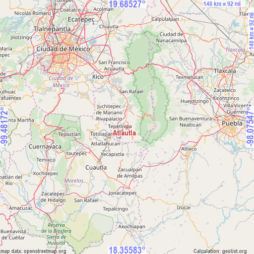
Atlautla GPS coordinates[2]
19° 1' 18.768" North, 98° 46' 42.924" West
| Map corner | latitude | longitude |
|---|---|---|
| Upper-left | 19.68527°, | -99.48172° |
| Center: | 19.02188°, | -98.77859° |
| Lower-right: | 18.35583°, | -98.07547° |
| Map W x H: | 147.8×147.8 km | = 91.8×91.8mi |
| max Lat: | 32.7° ⇑64.3% North |
| Atlautla: | 19.02188° |
| min Lat: | ⇓35.7% South 14.53588° |
| min Long | Atlautla | max Long |
| -117.105° | -98.77859° | -86.73105° |
| W 53.9%⇐ | ⇒46.1% E |
Elevation
Elevation of Atlautla is 2365 m = 7759 ft, and this is 1111.3 m = 3646 ft above average elevation for this country.
| Max E: |
3497 m = 11473 ft | 11.2% |
| Atlautla | 2365 m 7759 ft | |
| Avg. | 1253.7 m = 4113 ft | |
Min E: |
-1 m = -3 ft | 88.8% |
See also: Mexico elevation on elevation.city.
Geographical zone
Atlautla is located in North Torrid zone (between Equator and Tropic of Cancer). Distance of this Northern Tropic circle is 490.9 km =305 mi to North.| Distance of | km | miles | from Atlautla |
|---|---|---|---|
| North Pole | 7892 | 4903.9 | to North |
| Arctic Circle | 5286.1 | 3284.6 | to North |
| Tropic Cancer | 490.9 | 305 | to North |
| Equator | 2115 | 1314.2 | to South |


Nearby cities:
15 places around Atlautla: (largest is in red/bold)
• Colonia Guadalupe Hidalgo
7 km =4.3 mi,  213°
213°
• Cuecuecuatitla
6.9 km =4.3 mi,  262°
262°
• Las Delicias
5.5 km =3.4 mi,  357°
357°
• Ozumba de Alzate
2.4 km =1.5 mi,  313°
313°
• Popo Park
4.8 km =3 mi, 357°
• San Andrés Tlalamac
6.8 km =4.2 mi, 206°
• San José Tlacotitlán
4.9 km =3 mi,  215°
215°
• San Juan Tehuixtitlán
3.8 km =2.4 mi,  18°
18°
• San Juan Tepecoculco
4.4 km =2.7 mi,  192°
192°
• San Marcos Tecomaxusco
4.9 km =3 mi,  156°
156°
• San Mateo Tecalco
3.9 km =2.4 mi,  332°
332°
• San Vicente Chimalhuacán
2.4 km =1.5 mi,  275°
275°
• Santiago Mamalhuazuca
3.4 km =2.1 mi, 213°
• Tepetlixpa
4.6 km =2.9 mi, 279°
• Zoyatzingo
7.6 km =4.7 mi, 356°
Sources, notices
• [Note1] Compared only with cities in Mexico existing in our database
• [Src1] Map data: © OpenStreetMap contributors (CC-BY-SA)
• [Src2] Other city data from geonames.org with taken over terms of usage.
• [Src3] Geographical zone / Annual Mean Temperature by Robert A. Rohde @ Wikipedia
