Tepetlixpa geodata
Tepetlixpa (State of Mexico) is a seat of a second-order administrative division; located in Mexico in America/Mexico_City (GMT-6) time zone. With population of 13,239 people, there are 742 cities with bigger population in this country. Compared to other cities in Mexico, 64.2% of cities are located further ↑North; 53.3% of cities are located further ←West and 87.8% of cities have lower elevation than Tepetlixpa. Note1


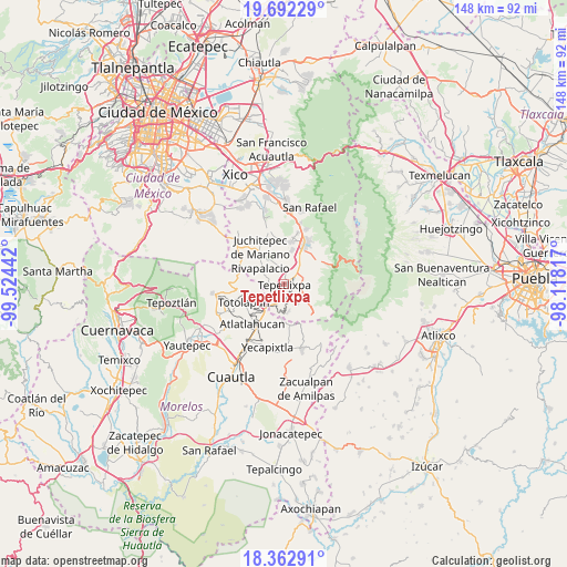
Tepetlixpa GPS coordinates[2]
19° 1' 44.148" North, 98° 49' 16.644" West
| Map corner | latitude | longitude |
|---|---|---|
| Upper-left | 19.69229°, | -99.52442° |
| Center: | 19.02893°, | -98.82129° |
| Lower-right: | 18.36291°, | -98.11817° |
| Map W x H: | 147.8×147.8 km | = 91.8×91.8mi |
| max Lat: | 32.7° ⇑64.2% North |
| Tepetlixpa: | 19.02893° |
| min Lat: | ⇓35.8% South 14.53588° |
| min Long | Tepetlixpa | max Long |
| -117.105° | -98.82129° | -86.73105° |
| W 53.3%⇐ | ⇒46.7% E |
Elevation
Elevation of Tepetlixpa is 2336 m = 7664 ft, and this is 1082.3 m = 3551 ft above average elevation for this country.
| Max E: |
3497 m = 11473 ft | 12.2% |
| Tepetlixpa | 2336 m 7664 ft | |
| Avg. | 1253.7 m = 4113 ft | |
Min E: |
-1 m = -3 ft | 87.8% |
See also: Mexico elevation on elevation.city.
Geographical zone
Tepetlixpa is located in North Torrid zone (between Equator and Tropic of Cancer). Distance of this Northern Tropic circle is 490.1 km =304.5 mi to North.| Distance of | km | miles | from Tepetlixpa |
|---|---|---|---|
| North Pole | 7891.2 | 4903.4 | to North |
| Arctic Circle | 5285.4 | 3284.2 | to North |
| Tropic Cancer | 490.1 | 304.5 | to North |
| Equator | 2115.8 | 1314.7 | to South |


Nearby cities:
15 places around Tepetlixpa: (largest is in red/bold)
• Atlautla
4.6 km =2.9 mi,  99°
99°
• Colonia Guadalupe Hidalgo
6.7 km =4.2 mi,  174°
174°
• Cuecuecuatitla
2.9 km =1.8 mi,  233°
233°
• Las Delicias
6.4 km =4 mi,  41°
41°
• Nepantla de Sor Juana Inés de la Cruz
5.8 km =3.6 mi,  200°
200°
• Ozumba de Alzate
2.9 km =1.8 mi,  72°
72°
• Popo Park
5.8 km =3.6 mi,  46°
46°
• San Andrés Tlalamac
7 km =4.3 mi, 168°
• San José Tlacotitlán
5.1 km =3.2 mi,  161°
161°
• San Juan Tehuixtitlán
6.3 km =3.9 mi,  63°
63°
• San Juan Tepecoculco
6.2 km =3.9 mi,  145°
145°
• San Mateo Tecalco
3.8 km =2.4 mi, 44°
• San Matías Cuijingo
7.1 km =4.4 mi,  331°
331°
• San Vicente Chimalhuacán
2.1 km =1.3 mi,  105°
105°
• Santiago Mamalhuazuca
4.5 km =2.8 mi,  143°
143°
Sources, notices
• [Note1] Compared only with cities in Mexico existing in our database
• [Src1] Map data: © OpenStreetMap contributors (CC-BY-SA)
• [Src2] Other city data from geonames.org with taken over terms of usage.
• [Src3] Geographical zone / Annual Mean Temperature by Robert A. Rohde @ Wikipedia
