Aquilastec geodata
Aquilastec (Hidalgo) is a populated place; located in Mexico in America/Mexico_City (GMT-6) time zone. With population of 633 people, there are 13682 cities with bigger population in this country. Compared to other cities in Mexico, 76.7% of cities are located further ↓South; 54.3% of cities are located further ←West and 58.6% of cities have higher elevation than Aquilastec. Note1


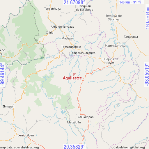
Aquilastec GPS coordinates[2]
21° 0' 57.888" North, 98° 45' 29.916" West
| Map corner | latitude | longitude |
|---|---|---|
| Upper-left | 21.67098°, | -99.46144° |
| Center: | 21.01608°, | -98.75831° |
| Lower-right: | 20.35829°, | -98.05519° |
| Map W x H: | 146×146 km | = 90.7×90.7mi |
| max Lat: | 32.7° ⇑23.3% North |
| Aquilastec: | 21.01608° |
| min Lat: | ⇓76.7% South 14.53588° |
| min Long | Aquilastec | max Long |
| -117.105° | -98.75831° | -86.73105° |
| W 54.3%⇐ | ⇒45.7% E |
Elevation
Elevation of Aquilastec is 1076 m = 3530 ft, and this is 177.7 m = 583 ft below average elevation for this country.
| Max E: |
3497 m = 11473 ft | 58.6% |
| Avg. | 1253.7 m = 4113 ft | |
| Aquilastec | 1076 m = 3530 ft | |
Min E: |
-1 m = -3 ft | 41.4% |
See also: Mexico elevation on elevation.city.
Geographical zone
Aquilastec is located in North Torrid zone (between Equator and Tropic of Cancer). Distance of this Northern Tropic circle is 269.1 km =167.2 mi to North.| Distance of | km | miles | from Aquilastec |
|---|---|---|---|
| North Pole | 7670.3 | 4766.1 | to North |
| Arctic Circle | 5064.4 | 3146.9 | to North |
| Tropic Cancer | 269.1 | 167.2 | to North |
| Equator | 2336.8 | 1452 | to South |


Nearby cities:
15 places around Aquilastec: (largest is in red/bold)
• Acayuca
6.1 km =3.8 mi,  202°
202°
• Acoxcatlán
5.2 km =3.2 mi, 203°
• Acuimantla
4.5 km =2.8 mi,  298°
298°
• Chipoco
7.3 km =4.5 mi,  128°
128°
• Cuxhuacan
7.9 km =4.9 mi,  230°
230°
• Hueyapa
10.5 km =6.5 mi,  43°
43°
• Huitepec
5.6 km =3.5 mi, 40°
• Ixtlapala
3.8 km =2.4 mi,  85°
85°
• San Miguel Ayotempa
10.6 km =6.6 mi,  245°
245°
• Tamala
4.8 km =3 mi,  244°
244°
• Tepehuacán de Guerrero
8.7 km =5.4 mi,  268°
268°
• Teyahuala
9.7 km =6 mi,  292°
292°
• Tolago
5.2 km =3.2 mi,  143°
143°
• Xilitla
7.9 km =4.9 mi,  319°
319°
• Xuchitlán
5.5 km =3.4 mi,  15°
15°
Sources, notices
• [Note1] Compared only with cities in Mexico existing in our database
• [Src1] Map data: © OpenStreetMap contributors (CC-BY-SA)
• [Src2] Other city data from geonames.org with taken over terms of usage.
• [Src3] Geographical zone / Annual Mean Temperature by Robert A. Rohde @ Wikipedia
