Hueyapa geodata
Hueyapa (Hidalgo) is a populated place; located in Mexico in America/Mexico_City (GMT-6) time zone. With population of 1,478 people, there are 5841 cities with bigger population in this country. Compared to other cities in Mexico, 77.7% of cities are located further ↓South; 55.2% of cities are located further ←West and 60.2% of cities have higher elevation than Hueyapa. Note1


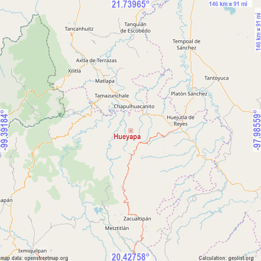
Hueyapa GPS coordinates[2]
21° 5' 6.216" North, 98° 41' 19.356" West
| Map corner | latitude | longitude |
|---|---|---|
| Upper-left | 21.73965°, | -99.39184° |
| Center: | 21.08506°, | -98.68871° |
| Lower-right: | 20.42758°, | -97.98559° |
| Map W x H: | 145.9×145.9 km | = 90.7×90.7mi |
| max Lat: | 32.7° ⇑22.3% North |
| Hueyapa: | 21.08506° |
| min Lat: | ⇓77.7% South 14.53588° |
| min Long | Hueyapa | max Long |
| -117.105° | -98.68871° | -86.73105° |
| W 55.2%⇐ | ⇒44.8% E |
Elevation
Elevation of Hueyapa is 989 m = 3245 ft, and this is 264.7 m = 868 ft below average elevation for this country.
| Max E: |
3497 m = 11473 ft | 60.2% |
| Avg. | 1253.7 m = 4113 ft | |
| Hueyapa | 989 m = 3245 ft | |
Min E: |
-1 m = -3 ft | 39.8% |
See also: Mexico elevation on elevation.city.
Geographical zone
Hueyapa is located in North Torrid zone (between Equator and Tropic of Cancer). Distance of this Northern Tropic circle is 261.5 km =162.5 mi to North.| Distance of | km | miles | from Hueyapa |
|---|---|---|---|
| North Pole | 7662.6 | 4761.3 | to North |
| Arctic Circle | 5056.7 | 3142.1 | to North |
| Tropic Cancer | 261.5 | 162.5 | to North |
| Equator | 2344.4 | 1456.7 | to South |


Nearby cities:
15 places around Hueyapa: (largest is in red/bold)
• Acoyotla
10.2 km =6.3 mi,  296°
296°
• Ahuatitla
9.2 km =5.7 mi,  14°
14°
• Aquilastec
10.5 km =6.5 mi,  223°
223°
• Cuatlimax
3.1 km =1.9 mi,  63°
63°
• Huitepec
4.9 km =3 mi,  226°
226°
• Huitzitzilingo
10.3 km =6.4 mi,  18°
18°
• Ixtlapala
8.2 km =5.1 mi,  205°
205°
• Jalpa
3.7 km =2.3 mi,  316°
316°
• Pahuayo
10 km =6.2 mi,  349°
349°
• Pueblo Hidalgo
3.4 km =2.1 mi, 18°
• San José
9.9 km =6.2 mi,  100°
100°
• Santa Lucía
8.8 km =5.5 mi, 347°
• Talol
7.5 km =4.7 mi, 58°
• Temango
5.2 km =3.2 mi,  357°
357°
• Xuchitlán
6.2 km =3.9 mi,  247°
247°
Sources, notices
• [Note1] Compared only with cities in Mexico existing in our database
• [Src1] Map data: © OpenStreetMap contributors (CC-BY-SA)
• [Src2] Other city data from geonames.org with taken over terms of usage.
• [Src3] Geographical zone / Annual Mean Temperature by Robert A. Rohde @ Wikipedia
