Acuimantla geodata
Acuimantla (Hidalgo) is a populated place; located in Mexico in America/Mexico_City (GMT-6) time zone. With population of 688 people, there are 12631 cities with bigger population in this country. Compared to other cities in Mexico, 77% of cities are located further ↓South; 53.7% of cities are located further ←West and 72.8% of cities have higher elevation than Acuimantla. Note1


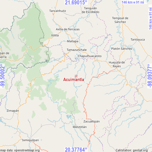
Acuimantla GPS coordinates[2]
21° 2' 7.224" North, 98° 47' 48.804" West
| Map corner | latitude | longitude |
|---|---|---|
| Upper-left | 21.69015°, | -99.50002° |
| Center: | 21.03534°, | -98.79689° |
| Lower-right: | 20.37764°, | -98.09377° |
| Map W x H: | 145.9×145.9 km | = 90.7×90.7mi |
| max Lat: | 32.7° ⇑23% North |
| Acuimantla: | 21.03534° |
| min Lat: | ⇓77% South 14.53588° |
| min Long | Acuimantla | max Long |
| -117.105° | -98.79689° | -86.73105° |
| W 53.7%⇐ | ⇒46.3% E |
Elevation
Elevation of Acuimantla is 299 m = 981 ft, and this is 954.7 m = 3132 ft below average elevation for this country.
| Max E: |
3497 m = 11473 ft | 72.8% |
| Avg. | 1253.7 m = 4113 ft | |
| Acuimantla | 299 m = 981 ft | |
Min E: |
-1 m = -3 ft | 27.2% |
See also: Mexico elevation on elevation.city.
Geographical zone
Acuimantla is located in North Torrid zone (between Equator and Tropic of Cancer). Distance of this Northern Tropic circle is 267 km =165.9 mi to North.| Distance of | km | miles | from Acuimantla |
|---|---|---|---|
| North Pole | 7668.2 | 4764.8 | to North |
| Arctic Circle | 5062.3 | 3145.6 | to North |
| Tropic Cancer | 267 | 165.9 | to North |
| Equator | 2338.9 | 1453.3 | to South |


Nearby cities:
15 places around Acuimantla: (largest is in red/bold)
• Acayuca
8 km =5 mi,  167°
167°
• Acoxcatlán
7.2 km =4.5 mi,  164°
164°
• Aquilastec
4.5 km =2.8 mi,  118°
118°
• Chilijapa
8.1 km =5 mi,  250°
250°
• Cuxhuacan
7.5 km =4.7 mi,  196°
196°
• Huitepec
8 km =5 mi,  74°
74°
• Ixtlapala
8 km =5 mi,  103°
103°
• La Reforma
8.7 km =5.4 mi,  298°
298°
• San Miguel Ayotempa
8.6 km =5.3 mi,  220°
220°
• Tamala
4.3 km =2.7 mi,  184°
184°
• Tepehuacán de Guerrero
5.3 km =3.3 mi,  242°
242°
• Texcapa
8.7 km =5.4 mi,  316°
316°
• Teyahuala
5.2 km =3.2 mi,  288°
288°
• Xilitla
4 km =2.5 mi,  344°
344°
• Xuchitlán
6.3 km =3.9 mi,  60°
60°
Sources, notices
• [Note1] Compared only with cities in Mexico existing in our database
• [Src1] Map data: © OpenStreetMap contributors (CC-BY-SA)
• [Src2] Other city data from geonames.org with taken over terms of usage.
• [Src3] Geographical zone / Annual Mean Temperature by Robert A. Rohde @ Wikipedia
