Huitepec geodata
Huitepec (Hidalgo) is a populated place; located in Mexico in America/Mexico_City (GMT-6) time zone. With population of 1,400 people, there are 6183 cities with bigger population in this country. Compared to other cities in Mexico, 77.3% of cities are located further ↓South; 54.7% of cities are located further ←West and 64.8% of cities have higher elevation than Huitepec. Note1


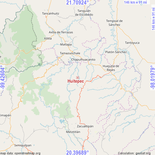
Huitepec GPS coordinates[2]
21° 3' 16.236" North, 98° 43' 22.476" West
| Map corner | latitude | longitude |
|---|---|---|
| Upper-left | 21.70924°, | -99.42604° |
| Center: | 21.05451°, | -98.72291° |
| Lower-right: | 20.39689°, | -98.01979° |
| Map W x H: | 145.9×145.9 km | = 90.7×90.7mi |
| max Lat: | 32.7° ⇑22.7% North |
| Huitepec: | 21.05451° |
| min Lat: | ⇓77.3% South 14.53588° |
| min Long | Huitepec | max Long |
| -117.105° | -98.72291° | -86.73105° |
| W 54.7%⇐ | ⇒45.3% E |
Elevation
Elevation of Huitepec is 697 m = 2287 ft, and this is 556.7 m = 1826 ft below average elevation for this country.
| Max E: |
3497 m = 11473 ft | 64.8% |
| Avg. | 1253.7 m = 4113 ft | |
| Huitepec | 697 m = 2287 ft | |
Min E: |
-1 m = -3 ft | 35.2% |
See also: Mexico elevation on elevation.city.
Geographical zone
Huitepec is located in North Torrid zone (between Equator and Tropic of Cancer). Distance of this Northern Tropic circle is 264.9 km =164.6 mi to North.| Distance of | km | miles | from Huitepec |
|---|---|---|---|
| North Pole | 7666 | 4763.4 | to North |
| Arctic Circle | 5060.1 | 3144.2 | to North |
| Tropic Cancer | 264.9 | 164.6 | to North |
| Equator | 2341 | 1454.6 | to South |


Nearby cities:
15 places around Huitepec: (largest is in red/bold)
• Acoyotla
9.7 km =6 mi,  324°
324°
• Acuimantla
8 km =5 mi,  254°
254°
• Aquilastec
5.6 km =3.5 mi,  220°
220°
• Chipoco
9.1 km =5.7 mi,  167°
167°
• Cuatlimax
7.9 km =4.9 mi,  52°
52°
• Hueyapa
4.9 km =3 mi, 46°
• Ixtlapala
4 km =2.5 mi,  179°
179°
• Jalpa
6.2 km =3.9 mi,  9°
9°
• Pueblo Hidalgo
8.1 km =5 mi,  34°
34°
• Tamala
10.2 km =6.3 mi,  231°
231°
• Temango
9.2 km =5.7 mi,  21°
21°
• Tlanchinol
9.7 km =6 mi,  135°
135°
• Tolago
8.5 km =5.3 mi, 183°
• Xilitla
8.9 km =5.5 mi,  281°
281°
• Xuchitlán
2.4 km =1.5 mi,  294°
294°
Sources, notices
• [Note1] Compared only with cities in Mexico existing in our database
• [Src1] Map data: © OpenStreetMap contributors (CC-BY-SA)
• [Src2] Other city data from geonames.org with taken over terms of usage.
• [Src3] Geographical zone / Annual Mean Temperature by Robert A. Rohde @ Wikipedia
