Acayuca geodata
Acayuca (Hidalgo) is a populated place; located in Mexico in America/Mexico_City (GMT-6) time zone. With population of 705 people, there are 12337 cities with bigger population in this country. Compared to other cities in Mexico, 76% of cities are located further ↓South; 53.9% of cities are located further ←West and 58.7% of cities have higher elevation than Acayuca. Note1


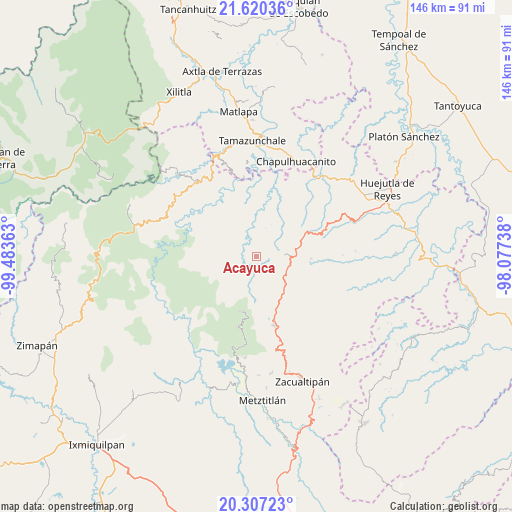
Acayuca GPS coordinates[2]
20° 57' 54.864" North, 98° 46' 49.8" West
| Map corner | latitude | longitude |
|---|---|---|
| Upper-left | 21.62036°, | -99.48363° |
| Center: | 20.96524°, | -98.7805° |
| Lower-right: | 20.30723°, | -98.07738° |
| Map W x H: | 146×146 km | = 90.7×90.7mi |
| max Lat: | 32.7° ⇑24% North |
| Acayuca: | 20.96524° |
| min Lat: | ⇓76% South 14.53588° |
| min Long | Acayuca | max Long |
| -117.105° | -98.7805° | -86.73105° |
| W 53.9%⇐ | ⇒46.1% E |
Elevation
Elevation of Acayuca is 1065 m = 3494 ft, and this is 188.7 m = 619 ft below average elevation for this country.
| Max E: |
3497 m = 11473 ft | 58.7% |
| Avg. | 1253.7 m = 4113 ft | |
| Acayuca | 1065 m = 3494 ft | |
Min E: |
-1 m = -3 ft | 41.3% |
See also: Mexico elevation on elevation.city.
Geographical zone
Acayuca is located in North Torrid zone (between Equator and Tropic of Cancer). Distance of this Northern Tropic circle is 274.8 km =170.8 mi to North.| Distance of | km | miles | from Acayuca |
|---|---|---|---|
| North Pole | 7675.9 | 4769.6 | to North |
| Arctic Circle | 5070.1 | 3150.4 | to North |
| Tropic Cancer | 274.8 | 170.8 | to North |
| Equator | 2331.1 | 1448.5 | to South |


Nearby cities:
15 places around Acayuca: (largest is in red/bold)
• Acoxcatlán
0.9 km =0.6 mi,  16°
16°
• Acuimantla
8 km =5 mi,  347°
347°
• Aquilastec
6.1 km =3.8 mi, 22°
• Chilijapa
10.6 km =6.6 mi,  298°
298°
• Chipoco
8.1 km =5 mi,  82°
82°
• Cuxhuacan
3.9 km =2.4 mi,  279°
279°
• Huitepec
11.6 km =7.2 mi,  31°
31°
• Ixculculla
6.6 km =4.1 mi,  265°
265°
• Ixtlapala
8.5 km =5.3 mi,  45°
45°
• San Antonio
9.9 km =6.2 mi,  214°
214°
• San Miguel Ayotempa
7.4 km =4.6 mi, 279°
• Tamala
4.1 km =2.5 mi,  330°
330°
• Tepehuacán de Guerrero
8.3 km =5.2 mi,  310°
310°
• Tolago
5.6 km =3.5 mi,  74°
74°
• Xuchitlán
11.6 km =7.2 mi, 19°
Sources, notices
• [Note1] Compared only with cities in Mexico existing in our database
• [Src1] Map data: © OpenStreetMap contributors (CC-BY-SA)
• [Src2] Other city data from geonames.org with taken over terms of usage.
• [Src3] Geographical zone / Annual Mean Temperature by Robert A. Rohde @ Wikipedia
