Angostura geodata
Angostura (Veracruz) is a populated place; located in Mexico in America/Mexico_City (GMT-6) time zone. With population of 748 people, there are 11708 cities with bigger population in this country. Compared to other cities in Mexico, 80.1% of cities are located further ↑North; 83.6% of cities are located further ←West and 76.3% of cities have higher elevation than Angostura. Note1


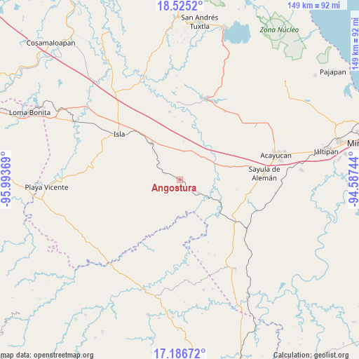
Angostura GPS coordinates[2]
17° 51' 25.992" North, 95° 17' 26.016" West
| Map corner | latitude | longitude |
|---|---|---|
| Upper-left | 18.5252°, | -95.99369° |
| Center: | 17.85722°, | -95.29056° |
| Lower-right: | 17.18672°, | -94.58744° |
| Map W x H: | 148.8×148.8 km | = 92.5×92.5mi |
| max Lat: | 32.7° ⇑80.1% North |
| Angostura: | 17.85722° |
| min Lat: | ⇓19.9% South 14.53588° |
| min Long | Angostura | max Long |
| -117.105° | -95.29056° | -86.73105° |
| W 83.6%⇐ | ⇒16.4% E |
Elevation
Elevation of Angostura is 175 m = 574 ft, and this is 1078.7 m = 3539 ft below average elevation for this country.
| Max E: |
3497 m = 11473 ft | 76.3% |
| Avg. | 1253.7 m = 4113 ft | |
| Angostura | 175 m = 574 ft | |
Min E: |
-1 m = -3 ft | 23.7% |
See also: Mexico elevation on elevation.city.
Geographical zone
Angostura is located in North Torrid zone (between Equator and Tropic of Cancer). Distance of this Northern Tropic circle is 620.4 km =385.5 mi to North.| Distance of | km | miles | from Angostura |
|---|---|---|---|
| North Pole | 8021.5 | 4984.3 | to North |
| Arctic Circle | 5415.6 | 3365.1 | to North |
| Tropic Cancer | 620.4 | 385.5 | to North |
| Equator | 1985.5 | 1233.7 | to South |


Nearby cities:
15 places around Angostura: (largest is in red/bold)
• Achotal de Moreno
21.3 km =13.2 mi,  128°
128°
• Aguapinole (Cuapinole)
22.7 km =14.1 mi,  55°
55°
• Bellaco
14 km =8.7 mi,  123°
123°
• Casas Viejas
14.8 km =9.2 mi,  13°
13°
• Chapopoapan
22.9 km =14.2 mi,  71°
71°
• Estación Juanita
9.4 km =5.8 mi, 124°
• Huayacanes
6.9 km =4.3 mi, 11°
• Juan Rodríguez Clara
19.1 km =11.9 mi,  322°
322°
• La Caudalosa
24 km =14.9 mi,  99°
99°
• La Lima
15.8 km =9.8 mi, 60°
• Loma de Hujuapan
19.1 km =11.9 mi,  25°
25°
• Los Tigres (San Marcos)
7.3 km =4.5 mi,  300°
300°
• Ojo de Agua
13.7 km =8.5 mi,  2°
2°
• Rancho Nuevo
23 km =14.3 mi, 74°
• San Juan Evangelista
16.3 km =10.1 mi,  78°
78°
Sources, notices
• [Note1] Compared only with cities in Mexico existing in our database
• [Src1] Map data: © OpenStreetMap contributors (CC-BY-SA)
• [Src2] Other city data from geonames.org with taken over terms of usage.
• [Src3] Geographical zone / Annual Mean Temperature by Robert A. Rohde @ Wikipedia
