Rancho Nuevo geodata
Rancho Nuevo (Veracruz) is a populated place; located in Mexico in America/Mexico_City (GMT-6) time zone. With population of 816 people, there are 10702 cities with bigger population in this country. Compared to other cities in Mexico, 79.6% of cities are located further ↑North; 84.4% of cities are located further ←West and 81.4% of cities have higher elevation than Rancho Nuevo. Note1


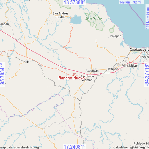
Rancho Nuevo GPS coordinates[2]
17° 54' 39.996" North, 95° 4' 49.008" West
| Map corner | latitude | longitude |
|---|---|---|
| Upper-left | 18.57888°, | -95.78341° |
| Center: | 17.91111°, | -95.08028° |
| Lower-right: | 17.24081°, | -94.37716° |
| Map W x H: | 148.8×148.8 km | = 92.5×92.5mi |
| max Lat: | 32.7° ⇑79.6% North |
| Rancho Nuevo: | 17.91111° |
| min Lat: | ⇓20.4% South 14.53588° |
| min Long | Rancho Nuevo | max Long |
| -117.105° | -95.08028° | -86.73105° |
| W 84.4%⇐ | ⇒15.6% E |
Elevation
Elevation of Rancho Nuevo is 77 m = 253 ft, and this is 1176.7 m = 3861 ft below average elevation for this country.
| Max E: |
3497 m = 11473 ft | 81.4% |
| Avg. | 1253.7 m = 4113 ft | |
| Rancho Nuevo | 77 m = 253 ft | |
Min E: |
-1 m = -3 ft | 18.6% |
See also: Mexico elevation on elevation.city.
Geographical zone
Rancho Nuevo is located in North Torrid zone (between Equator and Tropic of Cancer). Distance of this Northern Tropic circle is 614.4 km =381.8 mi to North.| Distance of | km | miles | from Rancho Nuevo |
|---|---|---|---|
| North Pole | 8015.5 | 4980.6 | to North |
| Arctic Circle | 5409.6 | 3361.4 | to North |
| Tropic Cancer | 614.4 | 381.8 | to North |
| Equator | 1991.5 | 1237.5 | to South |


Nearby cities:
15 places around Rancho Nuevo: (largest is in red/bold)
• Aguapinole (Cuapinole)
7.6 km =4.7 mi,  332°
332°
• Aguilera
13.1 km =8.1 mi,  148°
148°
• Chapopoapan
1.3 km =0.8 mi,  335°
335°
• Congregación Hidalgo
12 km =7.5 mi,  75°
75°
• Cruz del Milagro
7.4 km =4.6 mi,  92°
92°
• Dehesa
9.3 km =5.8 mi,  68°
68°
• El Hato
15.7 km =9.8 mi,  52°
52°
• Esperanza Malota
12.1 km =7.5 mi,  15°
15°
• La Caudalosa
10.1 km =6.3 mi,  172°
172°
• La Cerquilla
2.7 km =1.7 mi,  97°
97°
• La Lima
8.6 km =5.3 mi,  281°
281°
• Nuevo Poblado el Hato
12.1 km =7.5 mi, 76°
• San Juan Evangelista
6.9 km =4.3 mi,  246°
246°
• Sayula de Alemán
13.1 km =8.1 mi, 104°
• Vista Hermosa
2.5 km =1.6 mi,  55°
55°
Sources, notices
• [Note1] Compared only with cities in Mexico existing in our database
• [Src1] Map data: © OpenStreetMap contributors (CC-BY-SA)
• [Src2] Other city data from geonames.org with taken over terms of usage.
• [Src3] Geographical zone / Annual Mean Temperature by Robert A. Rohde @ Wikipedia
