Chapopoapan geodata
Chapopoapan (Veracruz) is a populated place; located in Mexico in America/Mexico_City (GMT-6) time zone. With population of 514 people, there are 16370 cities with bigger population in this country. Compared to other cities in Mexico, 79.4% of cities are located further ↑North; 84.3% of cities are located further ←West and 83.3% of cities have higher elevation than Chapopoapan. Note1


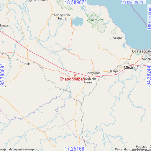
Chapopoapan GPS coordinates[2]
17° 55' 18.984" North, 95° 5' 8.016" West
| Map corner | latitude | longitude |
|---|---|---|
| Upper-left | 18.58967°, | -95.78869° |
| Center: | 17.92194°, | -95.08556° |
| Lower-right: | 17.25168°, | -94.38244° |
| Map W x H: | 148.8×148.8 km | = 92.5×92.5mi |
| max Lat: | 32.7° ⇑79.4% North |
| Chapopoapan: | 17.92194° |
| min Lat: | ⇓20.6% South 14.53588° |
| min Long | Chapopoapan | max Long |
| -117.105° | -95.08556° | -86.73105° |
| W 84.3%⇐ | ⇒15.7% E |
Elevation
Elevation of Chapopoapan is 58 m = 190 ft, and this is 1195.7 m = 3923 ft below average elevation for this country.
| Max E: |
3497 m = 11473 ft | 83.3% |
| Avg. | 1253.7 m = 4113 ft | |
| Chapopoapan | 58 m = 190 ft | |
Min E: |
-1 m = -3 ft | 16.7% |
See also: Mexico elevation on elevation.city.
Geographical zone
Chapopoapan is located in North Torrid zone (between Equator and Tropic of Cancer). Distance of this Northern Tropic circle is 613.2 km =381 mi to North.| Distance of | km | miles | from Chapopoapan |
|---|---|---|---|
| North Pole | 8014.3 | 4979.9 | to North |
| Arctic Circle | 5408.4 | 3360.6 | to North |
| Tropic Cancer | 613.2 | 381 | to North |
| Equator | 1992.7 | 1238.2 | to South |


Nearby cities:
15 places around Chapopoapan: (largest is in red/bold)
• Aguapinole (Cuapinole)
6.3 km =3.9 mi,  332°
332°
• Aguilera
14.4 km =8.9 mi,  148°
148°
• Congregación Hidalgo
12.3 km =7.6 mi,  81°
81°
• Cruz del Milagro
8 km =5 mi,  100°
100°
• Dehesa
9.5 km =5.9 mi, 76°
• El Hato
15.5 km =9.6 mi,  57°
57°
• Esperanza Malota
11.2 km =7 mi,  20°
20°
• La Caudalosa
11.4 km =7.1 mi,  170°
170°
• La Cerquilla
3.6 km =2.2 mi,  115°
115°
• La Lima
7.9 km =4.9 mi,  273°
273°
• Nuevo Poblado el Hato
12.5 km =7.8 mi, 82°
• Rancho Nuevo
1.3 km =0.8 mi,  155°
155°
• San Juan Evangelista
7 km =4.3 mi,  235°
235°
• Sayula de Alemán
14 km =8.7 mi,  108°
108°
• Vista Hermosa
2.6 km =1.6 mi,  85°
85°
Sources, notices
• [Note1] Compared only with cities in Mexico existing in our database
• [Src1] Map data: © OpenStreetMap contributors (CC-BY-SA)
• [Src2] Other city data from geonames.org with taken over terms of usage.
• [Src3] Geographical zone / Annual Mean Temperature by Robert A. Rohde @ Wikipedia
