Abala geodata
Abala (Yucatán) is a populated place; located in Mexico in America/Merida (GMT-6) time zone. With population of 1,890 people, there are 4603 cities with bigger population in this country. Compared to other cities in Mexico, 70.8% of cities are located further ↓South; 97.8% of cities are located further ←West and 93% of cities have higher elevation than Abala. Note1


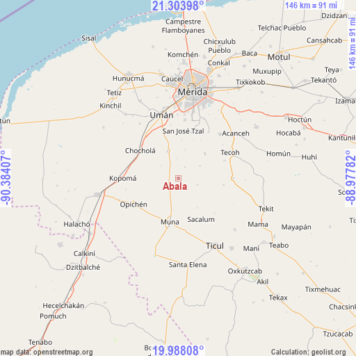
Abala GPS coordinates[2]
20° 38' 50.82" North, 89° 40' 51.384" West
| Map corner | latitude | longitude |
|---|---|---|
| Upper-left | 21.30398°, | -90.38407° |
| Center: | 20.64745°, | -89.68094° |
| Lower-right: | 19.98808°, | -88.97782° |
| Map W x H: | 146.3×146.3 km | = 90.9×90.9mi |
| max Lat: | 32.7° ⇑29.2% North |
| Abala: | 20.64745° |
| min Lat: | ⇓70.8% South 14.53588° |
| min Long | Abala | max Long |
| -117.105° | -89.68094° | -86.73105° |
| W 97.8%⇐ | ⇒2.2% E |
Elevation
Elevation of Abala is 17 m = 56 ft, and this is 1236.7 m = 4057 ft below average elevation for this country.
| Max E: |
3497 m = 11473 ft | 93% |
| Avg. | 1253.7 m = 4113 ft | |
| Abala | 17 m = 56 ft | |
Min E: |
-1 m = -3 ft | 7% |
See also: Mexico elevation on elevation.city.
Geographical zone
Abala is located in North Torrid zone (between Equator and Tropic of Cancer). Distance of this Northern Tropic circle is 310.1 km =192.7 mi to North.| Distance of | km | miles | from Abala |
|---|---|---|---|
| North Pole | 7711.3 | 4791.6 | to North |
| Arctic Circle | 5105.4 | 3172.3 | to North |
| Tropic Cancer | 310.1 | 192.7 | to North |
| Equator | 2295.8 | 1426.5 | to South |


Nearby cities:
15 places around Abala: (largest is in red/bold)
• Chochola
19.3 km =12 mi,  306°
306°
• Citincabchen
20.8 km =12.9 mi,  133°
133°
• Lepan
20.4 km =12.7 mi,  69°
69°
• Molas
19.5 km =12.1 mi,  15°
15°
• Muna
18.1 km =11.2 mi,  190°
190°
• Opichen
21.2 km =13.2 mi,  239°
239°
• Sacalum
19.2 km =11.9 mi,  150°
150°
• San Antonio Tzacalá
11.7 km =7.3 mi,  13°
13°
• San José Tipceh
20.7 km =12.9 mi,  176°
176°
• San José Tzal
19.8 km =12.3 mi, 6°
• Temozon Sur
5.3 km =3.3 mi,  33°
33°
• Uayalceh de Peón
10.3 km =6.4 mi,  60°
60°
• Xtepen
20.5 km =12.7 mi,  341°
341°
• Yaxcopoil
11.7 km =7.3 mi, 338°
• Yaxníc
17.1 km =10.6 mi, 22°
Sources, notices
• [Note1] Compared only with cities in Mexico existing in our database
• [Src1] Map data: © OpenStreetMap contributors (CC-BY-SA)
• [Src2] Other city data from geonames.org with taken over terms of usage.
• [Src3] Geographical zone / Annual Mean Temperature by Robert A. Rohde @ Wikipedia
