Opichen geodata
Opichen (Yucatán) is a populated place; located in Mexico in America/Merida (GMT-6) time zone. With population of 4,751 people, there are 1943 cities with bigger population in this country. Compared to other cities in Mexico, 68.9% of cities are located further ↓South; 97.7% of cities are located further ←West and 92.1% of cities have higher elevation than Opichen. Note1


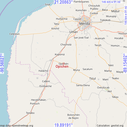
Opichen GPS coordinates[2]
20° 33' 6.084" North, 89° 51' 25.704" West
| Map corner | latitude | longitude |
|---|---|---|
| Upper-left | 21.20863°, | -90.56027° |
| Center: | 20.55169°, | -89.85714° |
| Lower-right: | 19.89191°, | -89.15402° |
| Map W x H: | 146.4×146.4 km | = 91×91mi |
| max Lat: | 32.7° ⇑31.1% North |
| Opichen: | 20.55169° |
| min Lat: | ⇓68.9% South 14.53588° |
| min Long | Opichen | max Long |
| -117.105° | -89.85714° | -86.73105° |
| W 97.7%⇐ | ⇒2.3% E |
Elevation
Elevation of Opichen is 19 m = 62 ft, and this is 1234.7 m = 4051 ft below average elevation for this country.
| Max E: |
3497 m = 11473 ft | 92.1% |
| Avg. | 1253.7 m = 4113 ft | |
| Opichen | 19 m = 62 ft | |
Min E: |
-1 m = -3 ft | 7.9% |
See also: Mexico elevation on elevation.city.
Geographical zone
Opichen is located in North Torrid zone (between Equator and Tropic of Cancer). Distance of this Northern Tropic circle is 320.8 km =199.3 mi to North.| Distance of | km | miles | from Opichen |
|---|---|---|---|
| North Pole | 7721.9 | 4798.2 | to North |
| Arctic Circle | 5116 | 3178.9 | to North |
| Tropic Cancer | 320.8 | 199.3 | to North |
| Equator | 2285.1 | 1419.9 | to South |


Nearby cities:
15 places around Opichen: (largest is in red/bold)
• Abala
21.2 km =13.2 mi,  59°
59°
• Bécal
21.5 km =13.4 mi,  235°
235°
• Calcehtoc
6 km =3.7 mi,  287°
287°
• Cepeda
26.8 km =16.7 mi,  259°
259°
• Chochola
22.3 km =13.9 mi,  7°
7°
• Halachó
24.7 km =15.3 mi,  250°
250°
• Kopoma
11.7 km =7.3 mi,  337°
337°
• Maxcanú
15.4 km =9.6 mi,  283°
283°
• Muna
16.5 km =10.3 mi,  115°
115°
• San José Tipceh
21.9 km =13.6 mi, 117°
• Santa Rosa
24.8 km =15.4 mi, 284°
• Santo Domingo
27.5 km =17.1 mi, 281°
• Temozon Sur
26 km =16.2 mi,  54°
54°
• Tepakán
25.7 km =16 mi,  228°
228°
• Yaxcopoil
25.7 km =16 mi,  33°
33°
Sources, notices
• [Note1] Compared only with cities in Mexico existing in our database
• [Src1] Map data: © OpenStreetMap contributors (CC-BY-SA)
• [Src2] Other city data from geonames.org with taken over terms of usage.
• [Src3] Geographical zone / Annual Mean Temperature by Robert A. Rohde @ Wikipedia
