Valerio Trujano geodata
Valerio Trujano (Oaxaca) is a populated place; located in Mexico in America/Mexico_City (GMT-6) time zone. With population of 869 people, there are 10053 cities with bigger population in this country. Compared to other cities in Mexico, 80.8% of cities are located further ↑North; 75.1% of cities are located further ←West and 66.1% of cities have higher elevation than Valerio Trujano. Note1


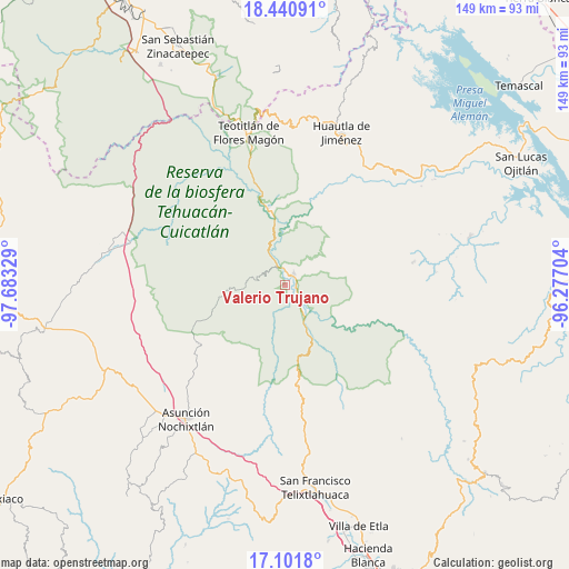
Valerio Trujano GPS coordinates[2]
17° 46' 21.396" North, 96° 58' 48.576" West
| Map corner | latitude | longitude |
|---|---|---|
| Upper-left | 18.44091°, | -97.68329° |
| Center: | 17.77261°, | -96.98016° |
| Lower-right: | 17.1018°, | -96.27704° |
| Map W x H: | 148.9×148.9 km | = 92.5×92.5mi |
| max Lat: | 32.7° ⇑80.8% North |
| Valerio Trujano: | 17.77261° |
| min Lat: | ⇓19.2% South 14.53588° |
| min Long | Valerio Trujano | max Long |
| -117.105° | -96.98016° | -86.73105° |
| W 75.1%⇐ | ⇒24.9% E |
Elevation
Elevation of Valerio Trujano is 630 m = 2067 ft, and this is 623.7 m = 2046 ft below average elevation for this country.
| Max E: |
3497 m = 11473 ft | 66.1% |
| Avg. | 1253.7 m = 4113 ft | |
| Valerio Trujano | 630 m = 2067 ft | |
Min E: |
-1 m = -3 ft | 33.9% |
See also: Mexico elevation on elevation.city.
Geographical zone
Valerio Trujano is located in North Torrid zone (between Equator and Tropic of Cancer). Distance of this Northern Tropic circle is 629.8 km =391.3 mi to North.| Distance of | km | miles | from Valerio Trujano |
|---|---|---|---|
| North Pole | 8030.9 | 4990.2 | to North |
| Arctic Circle | 5425 | 3370.9 | to North |
| Tropic Cancer | 629.8 | 391.3 | to North |
| Equator | 1976.1 | 1227.9 | to South |


Nearby cities:
15 places around Valerio Trujano: (largest is in red/bold)
• Concepción Pápalo
13 km =8.1 mi,  53°
53°
• Cuicatlan
4 km =2.5 mi,  33°
33°
• Jaltepetongo
11.3 km =7 mi,  211°
211°
• San Francisco Tutepetongo
12.3 km =7.6 mi,  120°
120°
• San José del Chilar
8.2 km =5.1 mi,  146°
146°
• San Juan Coyula
17.5 km =10.9 mi, 25°
• San Lorenzo Pápalo
16.4 km =10.2 mi,  40°
40°
• San Miguel Huautla
16.9 km =10.5 mi,  259°
259°
• San Miguel Huautla
17.6 km =10.9 mi, 258°
• San Pedro Chicozapotes
2.3 km =1.4 mi,  100°
100°
• San Pedro Jocotipac
10.5 km =6.5 mi,  267°
267°
• Santa María Pápalo
19.4 km =12.1 mi,  86°
86°
• Santos Reyes Pápalo
13.1 km =8.1 mi,  73°
73°
• Texcatitlán
11.3 km =7 mi,  233°
233°
• Tomellín
2.5 km =1.6 mi,  125°
125°
Sources, notices
• [Note1] Compared only with cities in Mexico existing in our database
• [Src1] Map data: © OpenStreetMap contributors (CC-BY-SA)
• [Src2] Other city data from geonames.org with taken over terms of usage.
• [Src3] Geographical zone / Annual Mean Temperature by Robert A. Rohde @ Wikipedia
