Jaltepetongo geodata
Jaltepetongo (Oaxaca) is a seat of a second-order administrative division; located in Mexico in America/Mexico_City (GMT-6) time zone. With population of 458 people, there are 16829 cities with bigger population in this country. Compared to other cities in Mexico, 81.4% of cities are located further ↑North; 74.4% of cities are located further ←West and 63.9% of cities have lower elevation than Jaltepetongo. Note1


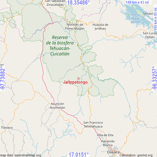
Jaltepetongo GPS coordinates[2]
17° 41' 10.428" North, 97° 2' 8.484" West
| Map corner | latitude | longitude |
|---|---|---|
| Upper-left | 18.35486°, | -97.73882° |
| Center: | 17.68623°, | -97.03569° |
| Lower-right: | 17.0151°, | -96.33257° |
| Map W x H: | 149×149 km | = 92.6×92.6mi |
| max Lat: | 32.7° ⇑81.4% North |
| Jaltepetongo: | 17.68623° |
| min Lat: | ⇓18.6% South 14.53588° |
| min Long | Jaltepetongo | max Long |
| -117.105° | -97.03569° | -86.73105° |
| W 74.4%⇐ | ⇒25.6% E |
Elevation
Elevation of Jaltepetongo is 1799 m = 5902 ft, and this is 545.3 m = 1789 ft above average elevation for this country.
| Max E: |
3497 m = 11473 ft | 36.1% |
| Jaltepetongo | 1799 m 5902 ft | |
| Avg. | 1253.7 m = 4113 ft | |
Min E: |
-1 m = -3 ft | 63.9% |
See also: Mexico elevation on elevation.city.
Geographical zone
Jaltepetongo is located in North Torrid zone (between Equator and Tropic of Cancer). Distance of this Northern Tropic circle is 639.4 km =397.3 mi to North.| Distance of | km | miles | from Jaltepetongo |
|---|---|---|---|
| North Pole | 8040.5 | 4996.1 | to North |
| Arctic Circle | 5434.6 | 3376.9 | to North |
| Tropic Cancer | 639.4 | 397.3 | to North |
| Equator | 1966.5 | 1221.9 | to South |


Nearby cities:
15 places around Jaltepetongo: (largest is in red/bold)
• Apoala
11.4 km =7.1 mi,  248°
248°
• Chicahua
17.8 km =11.1 mi, 251°
• Cuicatlan
15.3 km =9.5 mi,  31°
31°
• El Fortín Alto
19.2 km =11.9 mi,  243°
243°
• San Francisco Tutepetongo
16.7 km =10.4 mi,  78°
78°
• San José del Chilar
10.8 km =6.7 mi,  74°
74°
• San Miguel Huautla
12.6 km =7.8 mi,  301°
301°
• San Miguel Huautla
12.9 km =8 mi, 297°
• San Pedro Chicozapotes
12.3 km =7.6 mi,  41°
41°
• San Pedro Jocotipac
10.3 km =6.4 mi,  333°
333°
• Santa María Apazco
9 km =5.6 mi,  229°
229°
• Santos Reyes Pápalo
22.7 km =14.1 mi,  54°
54°
• Texcatitlán
4.4 km =2.7 mi,  312°
312°
• Tomellín
11.4 km =7.1 mi, 44°
• Valerio Trujano
11.3 km =7 mi, 31°
Sources, notices
• [Note1] Compared only with cities in Mexico existing in our database
• [Src1] Map data: © OpenStreetMap contributors (CC-BY-SA)
• [Src2] Other city data from geonames.org with taken over terms of usage.
• [Src3] Geographical zone / Annual Mean Temperature by Robert A. Rohde @ Wikipedia
