Rancho Viejo geodata
Rancho Viejo (Oaxaca) is a populated place; located in Mexico in America/Mexico_City (GMT-6) time zone. With population of 1,013 people, there are 8605 cities with bigger population in this country. Compared to other cities in Mexico, 95.4% of cities are located further ↑North; 64% of cities are located further ←West and 74.6% of cities have higher elevation than Rancho Viejo. Note1


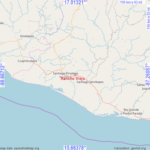
Rancho Viejo GPS coordinates[2]
16° 20' 22.776" North, 97° 57' 50.364" West
| Map corner | latitude | longitude |
|---|---|---|
| Upper-left | 17.01321°, | -98.66712° |
| Center: | 16.33966°, | -97.96399° |
| Lower-right: | 15.66378°, | -97.26087° |
| Map W x H: | 150×150 km | = 93.2×93.2mi |
| max Lat: | 32.7° ⇑95.4% North |
| Rancho Viejo: | 16.33966° |
| min Lat: | ⇓4.6% South 14.53588° |
| min Long | Rancho Viejo | max Long |
| -117.105° | -97.96399° | -86.73105° |
| W 64%⇐ | ⇒36% E |
Elevation
Elevation of Rancho Viejo is 232 m = 761 ft, and this is 1021.7 m = 3352 ft below average elevation for this country.
| Max E: |
3497 m = 11473 ft | 74.6% |
| Avg. | 1253.7 m = 4113 ft | |
| Rancho Viejo | 232 m = 761 ft | |
Min E: |
-1 m = -3 ft | 25.4% |
See also: Mexico elevation on elevation.city.
Geographical zone
Rancho Viejo is located in North Torrid zone (between Equator and Tropic of Cancer). Distance of this Northern Tropic circle is 789.1 km =490.3 mi to North.| Distance of | km | miles | from Rancho Viejo |
|---|---|---|---|
| North Pole | 8190.3 | 5089.2 | to North |
| Arctic Circle | 5584.4 | 3470 | to North |
| Tropic Cancer | 789.1 | 490.3 | to North |
| Equator | 1816.8 | 1128.9 | to South |


Nearby cities:
15 places around Rancho Viejo: (largest is in red/bold)
• Cruz del Itacuán
8.7 km =5.4 mi,  228°
228°
• Cubitán de Dolores
8.1 km =5 mi,  73°
73°
• El Carrizo
11.9 km =7.4 mi,  216°
216°
• Fraccionamiento San Isidro
11.2 km =7 mi,  283°
283°
• Piedra Blanca
9.5 km =5.9 mi,  201°
201°
• Pinotepa Nacional
9.5 km =5.9 mi,  270°
270°
• Pinotepa de Don Luis
9.8 km =6.1 mi,  352°
352°
• San Andrés Huaxpaltepec
5.2 km =3.2 mi,  102°
102°
• San Juan Colorado
13.5 km =8.4 mi,  4°
4°
• San Juan Yosocani
12.5 km =7.8 mi,  32°
32°
• San Lorenzo
11.4 km =7.1 mi,  57°
57°
• San Miguel Tetepelcingo
9.3 km =5.8 mi,  45°
45°
• Santa Catarina Mechoacán
13.5 km =8.4 mi,  91°
91°
• Santa María Huazolotitlán
6.8 km =4.2 mi,  126°
126°
• Santa María Jicaltepec
9.5 km =5.9 mi,  297°
297°
Sources, notices
• [Note1] Compared only with cities in Mexico existing in our database
• [Src1] Map data: © OpenStreetMap contributors (CC-BY-SA)
• [Src2] Other city data from geonames.org with taken over terms of usage.
• [Src3] Geographical zone / Annual Mean Temperature by Robert A. Rohde @ Wikipedia
