San Andrés Hidalgo geodata
San Andrés Hidalgo (Oaxaca) is a populated place; located in Mexico in America/Mexico_City (GMT-6) time zone. With population of 1,970 people, there are 4425 cities with bigger population in this country. Compared to other cities in Mexico, 77.1% of cities are located further ↑North; 77.2% of cities are located further ←West and 65.1% of cities have lower elevation than San Andrés Hidalgo. Note1


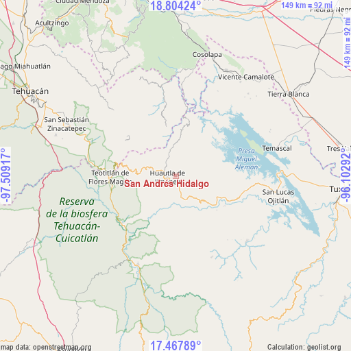
San Andrés Hidalgo GPS coordinates[2]
18° 8' 14.424" North, 96° 48' 21.744" West
| Map corner | latitude | longitude |
|---|---|---|
| Upper-left | 18.80424°, | -97.50917° |
| Center: | 18.13734°, | -96.80604° |
| Lower-right: | 17.46789°, | -96.10292° |
| Map W x H: | 148.6×148.6 km | = 92.3×92.3mi |
| max Lat: | 32.7° ⇑77.1% North |
| San Andrés Hidalgo: | 18.13734° |
| min Lat: | ⇓22.9% South 14.53588° |
| min Long | San Andrés Hid | max Long |
| -117.105° | -96.80604° | -86.73105° |
| W 77.2%⇐ | ⇒22.8% E |
Elevation
Elevation of San Andrés Hidalgo is 1833 m = 6014 ft, and this is 579.3 m = 1901 ft above average elevation for this country.
| Max E: |
3497 m = 11473 ft | 34.9% |
| San Andrés Hidalgo | 1833 m 6014 ft | |
| Avg. | 1253.7 m = 4113 ft | |
Min E: |
-1 m = -3 ft | 65.1% |
See also: Mexico elevation on elevation.city.
Geographical zone
San Andrés Hidalgo is located in North Torrid zone (between Equator and Tropic of Cancer). Distance of this Northern Tropic circle is 589.2 km =366.1 mi to North.| Distance of | km | miles | from San Andrés Hidalgo |
|---|---|---|---|
| North Pole | 7990.4 | 4965 | to North |
| Arctic Circle | 5384.5 | 3345.8 | to North |
| Tropic Cancer | 589.2 | 366.1 | to North |
| Equator | 2016.7 | 1253.1 | to South |


Nearby cities:
15 places around San Andrés Hidalgo: (largest is in red/bold)
• Agua de la Rosa
6.1 km =3.8 mi,  61°
61°
• El Carrizal
6.7 km =4.2 mi,  235°
235°
• Huautepec
4.1 km =2.5 mi,  164°
164°
• Huautla de Jiménez
3.7 km =2.3 mi,  259°
259°
• La Reforma San Mateo
6.8 km =4.2 mi,  265°
265°
• Llano de Agua
3.5 km =2.2 mi,  188°
188°
• Loma Chapultepec
4 km =2.5 mi, 240°
• Loma Chilar
2.3 km =1.4 mi,  283°
283°
• Río Santiago
5.1 km =3.2 mi,  108°
108°
• San Mateo Yoloxochitlán
6.6 km =4.1 mi, 275°
• Santa Catarina Buenavista
6.7 km =4.2 mi,  178°
178°
• Santa Cruz Acatepec
7.9 km =4.9 mi,  291°
291°
• Santa Cruz de Juárez
3.4 km =2.1 mi,  295°
295°
• Santa María la Asunción
3.6 km =2.2 mi,  202°
202°
• Xochitonalco
6.5 km =4 mi,  223°
223°
Sources, notices
• [Note1] Compared only with cities in Mexico existing in our database
• [Src1] Map data: © OpenStreetMap contributors (CC-BY-SA)
• [Src2] Other city data from geonames.org with taken over terms of usage.
• [Src3] Geographical zone / Annual Mean Temperature by Robert A. Rohde @ Wikipedia
