San Mateo Yoloxochitlán geodata
San Mateo Yoloxochitlán (Oaxaca) is a seat of a second-order administrative division; located in Mexico in America/Mexico_City (GMT-6) time zone. With population of 2,650 people, there are 3332 cities with bigger population in this country. Compared to other cities in Mexico, 77% of cities are located further ↑North; 76.4% of cities are located further ←West and 54.4% of cities have lower elevation than San Mateo Yoloxochitlán. Note1
Current local time in San Mateo Yoloxochitlán:
08:26 AM, WednesdayDifference from your time zone: hours


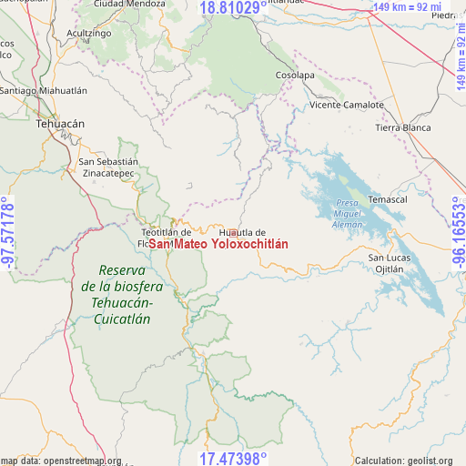
San Mateo Yoloxochitlán GPS coordinates[2]
18° 8' 36.276" North, 96° 52' 7.14" West
| Map corner | latitude | longitude |
|---|---|---|
| Upper-left | 18.81029°, | -97.57178° |
| Center: | 18.14341°, | -96.86865° |
| Lower-right: | 17.47398°, | -96.16553° |
| Map W x H: | 148.6×148.6 km | = 92.3×92.3mi |
| max Lat: | 32.7° ⇑77% North |
| San Mateo Yoloxochitlán: | 18.14341° |
| min Lat: | ⇓23% South 14.53588° |
| min Long | San Mateo Yolox | max Long |
| -117.105° | -96.86865° | -86.73105° |
| W 76.4%⇐ | ⇒23.6% E |
Elevation
Elevation of San Mateo Yoloxochitlán is 1571 m = 5154 ft, and this is 317.3 m = 1041 ft above average elevation for this country.
| Max E: |
3497 m = 11473 ft | 45.6% |
| San Mateo Yoloxochitlán | 1571 m 5154 ft | |
| Avg. | 1253.7 m = 4113 ft | |
Min E: |
-1 m = -3 ft | 54.4% |
See also: Mexico elevation on elevation.city.
Geographical zone
San Mateo Yoloxochitlán is located in North Torrid zone (between Equator and Tropic of Cancer). Distance of this Northern Tropic circle is 588.6 km =365.7 mi to North.| Distance of | km | miles | from San Mateo Yoloxochitlán |
|---|---|---|---|
| North Pole | 7989.7 | 4964.6 | to North |
| Arctic Circle | 5383.8 | 3345.3 | to North |
| Tropic Cancer | 588.6 | 365.7 | to North |
| Equator | 2017.4 | 1253.6 | to South |


Nearby cities:
15 places around San Mateo Yoloxochitlán: (largest is in red/bold)
• El Carrizal
4.6 km =2.9 mi,  165°
165°
• Eloxochitlán de Flores Magón
3.8 km =2.4 mi,  349°
349°
• Huautla de Jiménez
3.2 km =2 mi,  114°
114°
• La Reforma San Mateo
1.2 km =0.7 mi,  185°
185°
• Llano de Agua
7.4 km =4.6 mi,  124°
124°
• Loma Chapultepec
4.1 km =2.5 mi,  130°
130°
• Loma Chilar
4.4 km =2.7 mi,  92°
92°
• San Andrés Hidalgo
6.6 km =4.1 mi,  95°
95°
• San Jerónimo Tecóatl
5.3 km =3.3 mi,  298°
298°
• San Lucas Zoquiápam
4 km =2.5 mi,  259°
259°
• San Pedro Ocopetatillo
6.6 km =4.1 mi,  316°
316°
• Santa Cruz Acatepec
2.4 km =1.5 mi,  343°
343°
• Santa Cruz de Juárez
3.6 km =2.2 mi,  77°
77°
• Santa María la Asunción
6.6 km =4.1 mi, 127°
• Xochitonalco
5.8 km =3.6 mi,  158°
158°
Sources, notices
• [Note1] Compared only with cities in Mexico existing in our database
• [Src1] Map data: © OpenStreetMap contributors (CC-BY-SA)
• [Src2] Other city data from geonames.org with taken over terms of usage.
• [Src3] Geographical zone / Annual Mean Temperature by Robert A. Rohde @ Wikipedia
