Santa Cruz Acatepec geodata
Santa Cruz Acatepec (Oaxaca) is a seat of a second-order administrative division; located in Mexico in America/Mexico_City (GMT-6) time zone. With population of 1,127 people, there are 7691 cities with bigger population in this country. Compared to other cities in Mexico, 76.6% of cities are located further ↑North; 76.3% of cities are located further ←West and 56.4% of cities have lower elevation than Santa Cruz Acatepec. Note1


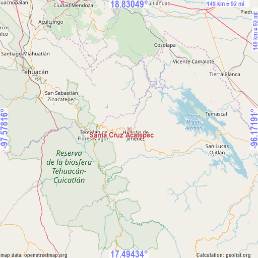
Santa Cruz Acatepec GPS coordinates[2]
18° 9' 49.284" North, 96° 52' 30.108" West
| Map corner | latitude | longitude |
|---|---|---|
| Upper-left | 18.83049°, | -97.57816° |
| Center: | 18.16369°, | -96.87503° |
| Lower-right: | 17.49434°, | -96.17191° |
| Map W x H: | 148.6×148.6 km | = 92.3×92.3mi |
| max Lat: | 32.7° ⇑76.6% North |
| Santa Cruz Acatepec: | 18.16369° |
| min Lat: | ⇓23.4% South 14.53588° |
| min Long | Santa Cruz Acat | max Long |
| -117.105° | -96.87503° | -86.73105° |
| W 76.3%⇐ | ⇒23.7% E |
Elevation
Elevation of Santa Cruz Acatepec is 1634 m = 5361 ft, and this is 380.3 m = 1248 ft above average elevation for this country.
| Max E: |
3497 m = 11473 ft | 43.6% |
| Santa Cruz Acatepec | 1634 m 5361 ft | |
| Avg. | 1253.7 m = 4113 ft | |
Min E: |
-1 m = -3 ft | 56.4% |
See also: Mexico elevation on elevation.city.
Geographical zone
Santa Cruz Acatepec is located in North Torrid zone (between Equator and Tropic of Cancer). Distance of this Northern Tropic circle is 586.3 km =364.3 mi to North.| Distance of | km | miles | from Santa Cruz Acatepec |
|---|---|---|---|
| North Pole | 7987.4 | 4963.1 | to North |
| Arctic Circle | 5381.6 | 3344 | to North |
| Tropic Cancer | 586.3 | 364.3 | to North |
| Equator | 2019.6 | 1254.9 | to South |


Nearby cities:
15 places around Santa Cruz Acatepec: (largest is in red/bold)
• El Carrizal
6.9 km =4.3 mi,  164°
164°
• Eloxochitlán de Flores Magón
1.5 km =0.9 mi,  358°
358°
• Huautla de Jiménez
5.1 km =3.2 mi,  134°
134°
• Huehuetlán Segunda Sección
8 km =5 mi,  295°
295°
• La Reforma San Mateo
3.5 km =2.2 mi,  170°
170°
• Loma Chapultepec
6.2 km =3.9 mi,  142°
142°
• Loma Chilar
5.6 km =3.5 mi,  115°
115°
• San Andrés Hidalgo
7.9 km =4.9 mi,  111°
111°
• San Jerónimo Tecóatl
4 km =2.5 mi,  274°
274°
• San Lorenzo Cuaunecuiltitla
6.2 km =3.9 mi,  319°
319°
• San Lucas Zoquiápam
4.4 km =2.7 mi,  226°
226°
• San Mateo Yoloxochitlán
2.4 km =1.5 mi, 163°
• San Pedro Ocopetatillo
4.6 km =2.9 mi, 303°
• Santa Cruz de Juárez
4.4 km =2.7 mi, 109°
• Xochitonalco
8.2 km =5.1 mi, 159°
Sources, notices
• [Note1] Compared only with cities in Mexico existing in our database
• [Src1] Map data: © OpenStreetMap contributors (CC-BY-SA)
• [Src2] Other city data from geonames.org with taken over terms of usage.
• [Src3] Geographical zone / Annual Mean Temperature by Robert A. Rohde @ Wikipedia
