Cañamazal geodata
Cañamazal (Oaxaca) is a populated place; located in Mexico in America/Mexico_City (GMT-6) time zone. With population of 631 people, there are 13723 cities with bigger population in this country. Compared to other cities in Mexico, 71.8% of cities are located further ↑North; 79.7% of cities are located further ←West and 78.8% of cities have higher elevation than Cañamazal. Note1


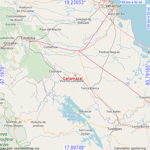
Cañamazal GPS coordinates[2]
18° 33' 55.116" North, 96° 29' 41.172" West
| Map corner | latitude | longitude |
|---|---|---|
| Upper-left | 19.23053°, | -97.1979° |
| Center: | 18.56531°, | -96.49477° |
| Lower-right: | 17.89749°, | -95.79165° |
| Map W x H: | 148.2×148.2 km | = 92.1×92.1mi |
| max Lat: | 32.7° ⇑71.8% North |
| Cañamazal: | 18.56531° |
| min Lat: | ⇓28.2% South 14.53588° |
| min Long | Cañamazal | max Long |
| -117.105° | -96.49477° | -86.73105° |
| W 79.7%⇐ | ⇒20.3% E |
Elevation
Elevation of Cañamazal is 115 m = 377 ft, and this is 1138.7 m = 3736 ft below average elevation for this country.
| Max E: |
3497 m = 11473 ft | 78.8% |
| Avg. | 1253.7 m = 4113 ft | |
| Cañamazal | 115 m = 377 ft | |
Min E: |
-1 m = -3 ft | 21.2% |
See also: Mexico elevation on elevation.city.
Geographical zone
Cañamazal is located in North Torrid zone (between Equator and Tropic of Cancer). Distance of this Northern Tropic circle is 541.7 km =336.6 mi to North.| Distance of | km | miles | from Cañamazal |
|---|---|---|---|
| North Pole | 7942.8 | 4935.4 | to North |
| Arctic Circle | 5336.9 | 3316.2 | to North |
| Tropic Cancer | 541.7 | 336.6 | to North |
| Equator | 2064.3 | 1282.7 | to South |


Nearby cities:
15 places around Cañamazal: (largest is in red/bold)
• Acatlán de Pérez Figueroa
12 km =7.5 mi,  256°
256°
• Arroyo de Enmedio
9.4 km =5.8 mi,  216°
216°
• Barbasco
7.2 km =4.5 mi,  286°
286°
• El Amate
12.1 km =7.5 mi,  102°
102°
• El Porvenir
6.6 km =4.1 mi,  164°
164°
• El Quechuleño
5.2 km =3.2 mi,  85°
85°
• Huixcolotla
11.2 km =7 mi,  358°
358°
• La Defensa
8.6 km =5.3 mi,  214°
214°
• Paso Nuevo
9.7 km =6 mi,  297°
297°
• Rodríguez Tejeda
11.2 km =7 mi,  48°
48°
• Salvador Gonzalo García
10.9 km =6.8 mi, 48°
• Serenilla de Abajo
10.7 km =6.6 mi, 87°
• Tetela
7.3 km =4.5 mi,  148°
148°
• Vicente Camalote
6.7 km =4.2 mi, 212°
• Zona Urbana Ejidal
10.6 km =6.6 mi,  249°
249°
Sources, notices
• [Note1] Compared only with cities in Mexico existing in our database
• [Src1] Map data: © OpenStreetMap contributors (CC-BY-SA)
• [Src2] Other city data from geonames.org with taken over terms of usage.
• [Src3] Geographical zone / Annual Mean Temperature by Robert A. Rohde @ Wikipedia
