Huixcolotla geodata
Huixcolotla (Veracruz) is a populated place; located in Mexico in America/Mexico_City (GMT-6) time zone. With population of 1,265 people, there are 6842 cities with bigger population in this country. Compared to other cities in Mexico, 70.6% of cities are located further ↑North; 79.7% of cities are located further ←West and 77.5% of cities have higher elevation than Huixcolotla. Note1


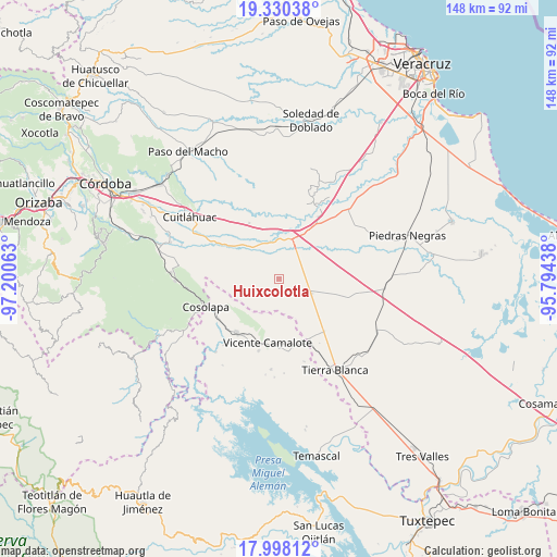
Huixcolotla GPS coordinates[2]
18° 39' 56.016" North, 96° 29' 51" West
| Map corner | latitude | longitude |
|---|---|---|
| Upper-left | 19.33038°, | -97.20063° |
| Center: | 18.66556°, | -96.4975° |
| Lower-right: | 17.99812°, | -95.79438° |
| Map W x H: | 148.1×148.1 km | = 92×92mi |
| max Lat: | 32.7° ⇑70.6% North |
| Huixcolotla: | 18.66556° |
| min Lat: | ⇓29.4% South 14.53588° |
| min Long | Huixcolotla | max Long |
| -117.105° | -96.4975° | -86.73105° |
| W 79.7%⇐ | ⇒20.3% E |
Elevation
Elevation of Huixcolotla is 142 m = 466 ft, and this is 1111.7 m = 3647 ft below average elevation for this country.
| Max E: |
3497 m = 11473 ft | 77.5% |
| Avg. | 1253.7 m = 4113 ft | |
| Huixcolotla | 142 m = 466 ft | |
Min E: |
-1 m = -3 ft | 22.5% |
See also: Mexico elevation on elevation.city.
Geographical zone
Huixcolotla is located in North Torrid zone (between Equator and Tropic of Cancer). Distance of this Northern Tropic circle is 530.5 km =329.6 mi to North.| Distance of | km | miles | from Huixcolotla |
|---|---|---|---|
| North Pole | 7931.6 | 4928.5 | to North |
| Arctic Circle | 5325.8 | 3309.3 | to North |
| Tropic Cancer | 530.5 | 329.6 | to North |
| Equator | 2075.4 | 1289.6 | to South |


Nearby cities:
15 places around Huixcolotla: (largest is in red/bold)
• Barbasco
11.2 km =7 mi,  216°
216°
• Cañamazal
11.2 km =7 mi,  178°
178°
• Cerro Alto
13.4 km =8.3 mi,  349°
349°
• Colonia Primero de Mayo
12.3 km =7.6 mi,  269°
269°
• El Quechuleño
12.1 km =7.5 mi,  153°
153°
• La Campana
9.4 km =5.8 mi,  29°
29°
• La Tinaja
11.2 km =7 mi,  19°
19°
• Loma Mulato
13.1 km =8.1 mi,  296°
296°
• Loma del Izote (Mata Planta)
12.1 km =7.5 mi,  247°
247°
• Los Mangos
14.2 km =8.8 mi,  105°
105°
• Palma Sola
14.4 km =8.9 mi, 249°
• Paso Nuevo
10.7 km =6.6 mi,  231°
231°
• Rodríguez Tejeda
9.4 km =5.8 mi, 113°
• Salvador Gonzalo García
9.3 km =5.8 mi, 114°
• Serenilla de Abajo
15.3 km =9.5 mi,  134°
134°
Sources, notices
• [Note1] Compared only with cities in Mexico existing in our database
• [Src1] Map data: © OpenStreetMap contributors (CC-BY-SA)
• [Src2] Other city data from geonames.org with taken over terms of usage.
• [Src3] Geographical zone / Annual Mean Temperature by Robert A. Rohde @ Wikipedia
